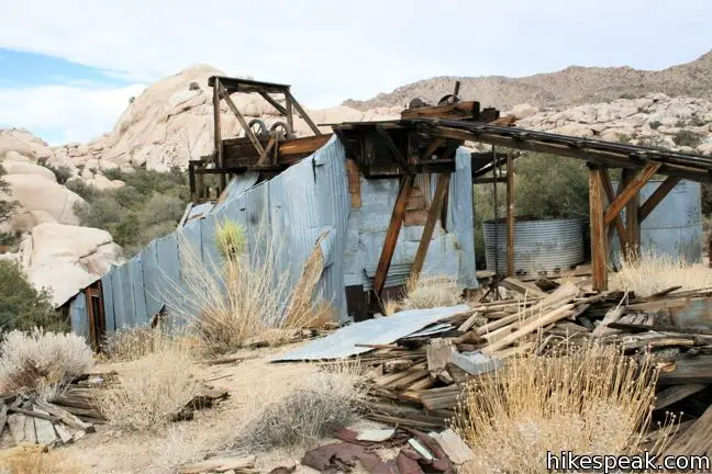
For the first half of the 20th century, the desert land now known as Joshua Tree National Park was scattered with miners on the hunt for gold and silver. When ore was mined, it was sent to a mill to be crushed and have the precious metal extracted. The ore from Desert Queen Mine and other mining operations passed through Wall Street Mill, which is located in Queen Valley near the Wonderland of Rocks. Today Wall Street Mill is considered the best-preserved gold mill in Joshua Tree and listed in the National Register of Historic Places.
The level hike to Wall Street Mill has two trailheads. The first is the main Wonderland of Rocks trailhead, which also provides access to Barker Dam. A second parking area, 0.3 miles up the trail, is located just off the unpaved Queen Valley Road. Starting from the first trailhead makes for a 2.15-mile round trip hike, which can be abbreviated to 1.55 miles by starting from the second trailhead.
A National Park Service sign at the main trailhead explains how the mill came to be:
During the Depression, the mining regions here experienced a second gold rush. As miners arrived, long-time rancher-miner Bill Keys recognized the need for a gold processing mill. In 1930 he bough the Wall Street Mill site, which had an existing well. Keys gathered the stamp mill and other machinery from area mine and mill sites to assemble his mill. For a fee, he processed ore for small-mine operations. When the gold was removed from the ore, it went back to the miner, to a smelter in Mojave, or to the U.S. Mint in San Francisco. Keys ran the mill on an as-needed basis, last using it in 1966.
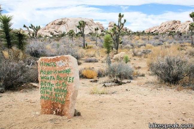
The history of the mill’s proprietor, Bill Keys, is interesting too. He had a property disputer with his neighbor, Worth Bagley, over control of the road accessing the mill. Their argument escalated, a gun was fired, and Mr. Bagley was killed. Following this western shootout, Keys was convicted of murder and sent away to San Quentin Prison. He was released after five years when a judge pardoned Keys, ruling that Bagley had been killed in self-defense. Look for a memorial 0.8 miles up the trail making the spot of the gunfight.

From the Wonderland of Rocks trailhead, take the track to the right of the bathrooms heading northeast toward Wall Street Mill. After 0.3 miles, the trail crosses the second trailhead, then continues another 0.77-miles to the mill.
The trail splits just past the parking area. To the left, a side trail extends a tenth of a mile to the ruins of Wonderland Ranch, a pink house at the bottom of Wonderland Wash. Continue straight through the junction toward Wall Street Mill.

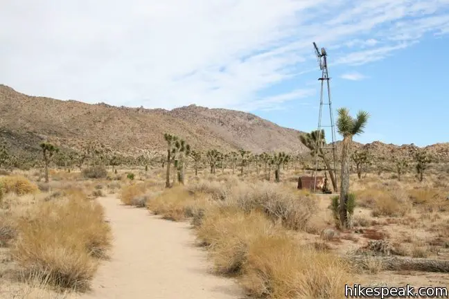
An old windmill rises from the desert floor, just to the right of the trail, 0.3 miles from second trailhead. This relic of the old west is trapped in time, a rusting spire in an arid landscape. After another 0.2 miles, the level Joshua tree-lined trail comes the memorial for Worth Bagley. The monument reads:
Here is where Worth Bagley bit the dust at the hand of W.F.Keys. May 11, 1943
A short distance past the duel-stone, the trail drops into a sandy trench, which it follows for the final 0.2 miles to Wall Street Mill.
A detailed blueprint from 1931 is displayed at the site, depicting how this two-stamp mill processed ore into gold. Many elements shown in the schematic are still in place.
Walk past the old well and pump up to Wall Street Mill, where the rail tracks, winch, and mill shed have endured abandonment. With a few renovations (and a small dose of TLC) Wall Street Mill could be back in business, extracting gold with its trusty twelve horsepower gasoline engine. The mill is bordered by boulder piles of White Tank Granite, the signature backdrop of Joshua Tree National Park.
After exploring the slowly decaying ruins, return the way you came for a 1.55 to 2.15-mile hike with 115 feet of elevation gain. To extend the trek, make a side trip to the Wonderland Ranch ruins or hike farther up Wonderland Wash.

To get to the trailhead: The turnoff for Barker Dam/Wall Street Mill is located on Park Boulevard 12 miles west of the intersection with Pinto Basin Road (and 1.6 miles north of the intersection with Keys View Road). From the well-marked turnoff, drive north for 1.5 miles to the large parking area for the Wonderland of Rocks. To reach the second trailhead, turn right on Queen Valley Road just before the parking area. Make the next left off the dirt road and drive a quarter-mile to a smaller parking lot. Both trailheads have bathrooms.
Trailhead address: Park Boulevard (Loop Road), Joshua Tree National Park, CA 92277
Trailhead coordinates: 34.0251, -116.1419 (34° 01′ 30.4″N 116° 08′ 30.8″W)
You may also view a regional map of surrounding California Desert trails and campgrounds.
 | Wonderland Wash This level 2.1-mile hike travels past the ruins of Wonderland Ranch up a use trail into the Wonderland of Rocks. |
 | Barker Dam This level 1.5-mile loop visits a small foreign-looking reservoir within the Wonderland of Rocks. |
 | Desert Queen Mine This 1.6-mile hike follows a level trail to an overlook before crossing a canyon to visits the ruins of one the most profitable gold mines in the California desert. |
 | Lucky Boy Vista This level 2.5-mile hike visits a modest overlook at the site of an old mine. |
 | Contact Mine This 3.9-mile hike ascends 700 feet up a wash, a canyon, and an old road to a mountainside mine site that offers a glimpse into the mining history of Joshua Tree. |
 | Fortynine Palms Oasis The 3-mile round trip hike visits a cool desert oasis. |
 | Indian Cove The 101-site campground is home to a 0.6-mile interpretive trail and endless bouldering and rock climbing opportunities. |
 | Hidden Valley This one mile loop circles the interior of a small valley surrounded by tall rocks that serves as an excellent bouldering arena. |
 | Lost Horse Mine This 4-mile hike visits a well-preserved mine and mill. |
 | Inspiration Peak This 1.2-mile hike leaves the crowds at Keys View for even grander views at a 5,550-foot summit that looks out on the Coachella Valley, the Salton Sea, Mount San Jacinto, and much of Joshua Tree National Park. |
 | Arch Rock This short hike leads to a natural arch in the granite formations by White Tank Campground. |
 | Cholla Cactus Garden This quarter-mile loop allows visitors to stroll through an intense concentration of cholla cacti. |
 | Mastodon Peak This 2.6-mile loop visits a 3,400-foot summit with panoramic views of southeastern Joshua Tree. |
 | Lost Palms Oasis This 7.2-mile hike visits a desert oasis nestled between mountains in the southeast corner of the park. |
 | Warren Peak This 5.5-mile hike summits a peak with impressive views over the west side of Joshua Tree. |
 | High View Nature Trail This 1 1/3-mile loop climbs a ridge on the west side of the park that offers views of San Gorgonio Mountain and Yucca Valley, along with an introduction to desert plants. |
 | Hikes in the California Desert Explore more trails in Death Valley National Park, Joshua Tree National Park, Anza-Borrego Desert State Park, and Mojave National Preserve. |
 | Joshua Tree Campgrounds Nine campgrounds with 500 total sites are spread throughout the park to facilitate your visit. |
 | Joshua Tree Wildflowers The desert in bloom is something any outdoor enthusiast in California should see. |


wow, thanks for all the trail suggestions! Im heading out to joshua tree for a day trip tomorrow and i’m so lucky to stumble upon this. It helps me out a lot! I love to explore especially ruins and unusual places.
[…] Wall St. Mill – Hikespeak […]
[…] Wall Street Stamp Mill trip description here […]
[…] Link for a map of the area […]