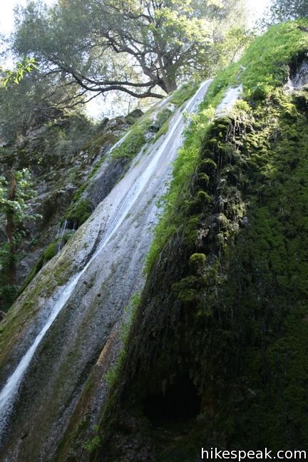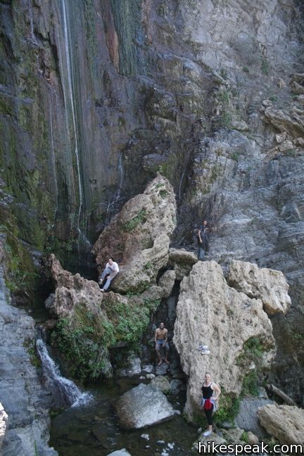
Rose Valley Falls is a magnificent two-tier 300-foot waterfall located on the west end of the Topatopa Mountains in Los Padres National Forest. Rose Valley Falls is the tallest waterfall in the range and while it is an easy hike to the base of the 100-foot tall lower tier of the waterfall (0.8 miles round trip with 150 feet of elevation gain), it is adventure to reach the more impressive upper tier.
Rose Valley Falls Trail begins from Rose Valley Campground, a 9-site first-come first serve campground. Set out from the back of the campground up a 0.4-mile long gradual trail to the base of the lower falls. An early creek crossing provides hope of a flowing waterfall. Bays and oaks provide enjoyable shade along a straightforward track. As you approach Lower Rose Valley Falls, cascades will appear in the creek to the left of the trail.
The lower falls of Rose Valley Falls is short and pleasant. The upper falls is long and impressive. However, much like Escondido Falls in Malibu, the trail from the lower falls to the upper is difficult and unmaintained.
Numerous footpaths have been created by bold hikes to get above the lower falls. This is because there isn’t really a good route up. Exercise caution if attempting to reach the upper falls as it requires a good deal of scrambling. If it is above your skill or comfort level, stay behind and relax by the lower falls.

The most obvious route is to the left of the lower falls. Cross the dirt bank along a thin footpath. Then follow the ridgeline up through the brush. Catch your breath when you reach the top of the rise, where the stunning upper falls is in sight. Carefully descend the slope of gravel scree down to the creek and boulder up to the foot of the falls.
In the summer, the water trickles down the long elegant black rock. The falls are enjoyable then, but early spring is the best time to see this waterfall at its boldest.

Need a place to camp? Rose Valley Campground is a free first-come first-serve campground right at the trailhead with nine sites for car campers circled close together in a field. Rose Valley Campground sports views of the falls, but lacks privacy.
Not far away is another small free campground, Middle Lion Campground, that offers more shade and privacy. A bit farther to the east is the Sespe Wilderness where backcountry camping is free and easy. If you intend to stay at either campground, arrive early or off weekends. Latecomers looking to camp will end up down the mountain at Wheeler Gorge Campground, a larger campground with fees. Consult the Forest Service website for additional camping options. A National Forest Adventure Pass is required.
Directions to the Trailhead
- Take the 101 Freeway to Ventura and head inland up Route 33 to Ojai.
- Continue another fifteen miles past Ojai into the mountains to the Sespe Road turnoff.
- There will be a sign for Rose Valley Falls.
- Drive 3 more miles and turn right on Chief Peak Road, which ends at the trailhead at Rose Valley Campground after half a mile.
- Display your Adventure Pass and start up the trail.
Trailhead Location
Trailhead address: Rose Valley Lake Road, Los Padres National Forest, Ojai, CA 93023
Campground coordinates: 34.5317, -119.1829 (34° 31′ 54.1″N 119° 10′ 58.4″W)
You may also view a regional map of surrounding Central Coast trails and campgrounds.
 | Wheeler Gorge This 1-mile loop explores the forest around this 70-site Campground. |
 | Sespe Creek to Willett Hot Springs This 19-miles round trip follows Sespe Creek to a relaxing hot springs. |
 | Horn Canyon Trail This 2.9-mile hike in Ojai goes up a canyon in the frontcountry of the Topatopa Mountains and ventures off trail along the soothing waters of Thacher Creek. |
 | Sisar Canyon Trail This 5.5 to 6.5-mile hike travels up a canyon to a viewpoint in the Topatopa Mountains between Ojai and Santa Paula. |
 | Santa Paula Canyon Trail to the Punchbowl This 8-mile hike ventures up rugged Santa Paula Canyon to a waterfall and a Punchbowl of pools and cascades in Santa Paula Creek by Big Cone Camp. |
 | Tangerine Falls This 2.5-mile hike visits a beautiful waterfall on the edge of Los Padres National Forest near Santa Barbara. |
 | Ocean's Edge and River's Edge Trails Loop This level and easy 1.5-mile loop in Emma Wood State Beach borders the Pacific Ocean, the Ventura River, and an estuary flocked by seabirds. |
 | More Central Coast Hikes Explore other destinations along the California coast between Ventura and Monterey, including trails in Los Padres National Forest. |
 | Nojoqui Falls This short 0.65-mile hike visits an 80-foot tall fern-lined waterfall. |
 | McWay Falls This 0.6-mile hike looks out on a stunning Big Sur waterfall that pours 80 feet right on to the beach. |
 | Salmon Creek Falls This short hike visits a fine 120-foot waterfall near the start of Salmon Creek Trail. |
 | Escondido Falls in the Santa Monica Mountains This 3.8-mile out and back hike visits a 200-foot waterfall that is split into two tiers. The upper tier is 150 feet tall and stunning after a rainstorm. |
 | Millard Falls in the San Gabriel Mountains This one mile hike visits a 50-foot waterfall up one of the most scenic canyons in the San Gabriels. |
 | Fish Canyon Falls in the San Gabriel Mountains This 4.8-mile round trip hike leaves from an active rock quarry and progresses up a beautiful canyon to a mesmerizing multi-tiered waterfall. |
 | San Antonio Falls in the San Gabriel Mountains This 1.4-mile hike visits a multi-tier waterfall along the trail to Mount Baldy. |
 | Tokopah Falls in Sequoia National Park This 4.2-mile hike reaches the base of the tallest waterfall in Sequoia National Park. |
 | Lower Yosemite Fall in Yosemite National Park This electrifying 1.2-mile hike delivers visitors to the base of the tallest waterfall in North America. |
Common Questions about Rose Valley Falls in Los Padres National Forest
- Is the trail open?
- Yes. You should expect to find that Rose Valley Falls is open. There are no recent reports of trail closures. If you discover that the trail is closed, please help your fellow hikers by reporting a closure.
- Do I need a permit for this hike?
- Yes. National Forest Adventure Pass.
- How much time does this hike take?
- It takes approximately 30 minutes to hike Rose Valley Falls. Individual hiking times vary. Add extra time for breaks and taking in the views.
- How long is this hike?
- The hike to Rose Valley Falls is a 0.8 mile out and back with 150 feet of elevation change.
- Are dogs allowed on this trail?
- Yes, dogs are allowed on Rose Valley Falls. The trail is open to hikers, dogs, bikes.
- Is Rose Valley Falls good for kids?
- Yes, this hike is likely suitable for children. It is relatively short (0.8 miles) with manageable elevation gain.
- Will I see a waterfall on this hike?
- Yes, Rose Valley Falls features a waterfall.
- Where is the trailhead located?
- The trailhead for Rose Valley Falls is located in Ojai, CA.
Trailhead Address:
Rose Valley Lake Road
Ojai, CA 93023
Trailhead Coordinates:
34.5317, -119.1829 - What are the driving directions to the start of the hike?
To get to the trailhead: Take the 101 Freeway to Ventura and head inland up Route 33 to Ojai. Continue another fifteen miles past Ojai into the mountains to the Sespe Road turnoff. There will be a sign for Rose Valley Falls. Drive 3 more miles and turn right on Chief Peak Road, which ends at the trailhead at Rose Valley Campground after half a mile. Display your Adventure Pass and start up the trail.
View custom Google Maps directions from your current location.
- Are there other trails near Rose Valley Falls?
- Yes, you can find other nearby hikes using the Hikespeak Hike Finder Map.


Is the lower fall accessible now? Do I need an adventure pass? If so, where can I obtain one?
Thank you.
The waterfall should be accessible. You will pass a ranger station near Wheeler Gorge Campground on the drive up to the falls where you can get more information and an adventure pass. The adventure pass programs seems to be getting phased out, so one may no longer be necessary.
Agreed. The people at Wheeler Gorge Campground are very helpful! When I visit this Falls, I stop there for a few minutes just to check in and see if there’s any new info or advisories about the area.
The Lower Falls is a great walk for all ages and abilities. The trail can get a bit full on the weekends. There is also a bit of trash along the trail, maybe from campers partying in the nearby car camping spot? All in all, the Lower Falls makes for a pleasant walk/hike, and the vistas while driving up to the spot are worthwhile.
Are the lower falls dog friendly?
you bet! Enjoy the hike. The waterfall should be flowing great!
I know it says to display adventure pass but is it really required? If so, how do I obtain one?
Hey, just went today…. No pass was required! Epic place
Does anyone know if the road is open again? It was closed this past Sunday, feb 19. Would love to go check this hike out
Is there water in the falls now?? 9-14-17
[…] Rose Valley Falls, two tiers and 300 feet tall, are pouring heavy after a month of intense storms that brought Ventura County out of the worst drought conditions. It is located 15 miles past Ojai, up Highway 33 off Sespe Road on the west end of the Topa Topa Mountains in Los Padres National Forest. For more information, go to http://www.hikespeak.com/trails/rose-valley-falls-padres/. […]
Wonderful short hike, dog friendly, awesome view of waterfall. No pass required!!!
Everyone Please…: PICK UP YOUR TRASH, PICK UP DOGGY POOPS AND BAG!!!
Is it stroller friendly?
BEAUTIFULL PLACE,CLEAN,DOG FRIENDLY AND THE WATERFALL IS GREAT
Can u get in the water?
Do u need a reservation to hike just for the day?