Rainbow Canyon Trail
in Anza-Borrego Desert State Park

For an exciting 2.2-mile hike on an undeveloped trail through a colorful canyon, make your way to Rainbow Canyon, located south of Blair Valley in Anza-Borrego Desert State Park. A bit of scrambling is required on this hike, to climb several sloped dry falls within the canyon. This hike has 300 feet of elevation gain between the trailhead and the turnaround point, with plenty to see along the way.
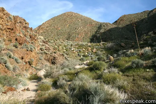
From the unmarked trailhead along route S2, begin hiking northeast toward Rainbow Canyon. Follow the path up the wash, crossing a metal fence toward the mouth of the canyon, 1/3 of a mile from the trailhead.
The alluvial fan below the canyon is surprisingly lush, populated by agave and cholla cacti. Ahead, these desert plants broaden the spectrum in the already colorful canyon. Rainbow Canyon does not appear to be a large water source, and one wonders how the vegetation can be so vibrant here. Aside from several smooth pour-overs, there is little evidence of water flowing down the canyon. Perhaps more is going on underground than meets the eye.

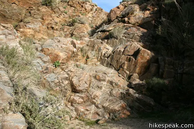
Not long after entering Rainbow Canyon, and just under half a mile from the start, you will arrive at the first of eight dry falls. Make your way over the angled six-foot dry falls and continue up the canyon through pronounced rock walls. None of the dry falls are too vertical or too challenging to be climbed by fit hikers, and ropes are not needed.
Rainbow Canyon carves through metamorphic rock that has been folded over into swirling colorful patterns (kind of like a rainbow). Layers of brown, red, and yellow, stand next to blacks and grays, while veins of mineral deposits add glistening lines to the spectacle. Rainbow Canyon offers an impressive display of the geological forces at work in the Anza-Borrego Desert. Take your time, and examine all the unique rocks along the way.
After the third dry falls, and 0.7 miles from the start, stay to the right at a fork in the canyon. Ahead, a few more dry falls come in quick succession, including a fun pair of dry falls that are nearly on top of each other. This is an excellent spot to gain a perched view down Rainbow Canyon.

At mile 1.1, the canyon tapers out and widens, becoming less adventurous. The canyon continues for another two miles toward the south end of Blair Valley, but turn around here and enjoy a fun descent over the ornately colored dry falls. Juniper trees appear along the slopes at the top of the canyon, serving as an indicator that you have reached the end of the hike (if you lost count of the dry falls).
This is an action-packed hike up a less-traveled canyon. No fee or permit is required to hike Rainbow Canyon in Anza-Borrego Desert State Park, so get out and enjoy.
To get to the trailhead: From Christmas Circle in Borrego Springs, drive 5 miles southwest on Borrego Springs Road. Turn right on Route S3 (Yaqui Pass Road) and drive 7 miles south over the ridge to Tamarisk Grove. Turn right on Route 78, and head west for another seven miles to Route S2. Turn left and drive 11 mile south, passing Blair Valley, to mile marker 27.7. Park on the east shoulder of the road, on the outside of a broad curve. Pick one of a few paths leaving the road that unite in the wash below Rainbow Canyon.
Trailhead address: Route S2 (Route Great Southern Overland Stage Route of 1849), Anza-Borrego Desert State Park, Julian, CA 92036
Trailhead coordinates: 32.99775, -116.44755 (32° 59′ 52″N 116° 26′ 51.2″W)
View Anza-Borrego Desert State Park in a larger map
Or view a regional map of surrounding California Desert trails and campgrounds.
 | Marshal South Home Trail This 1.3-mile hike ascends to the ruins of an adobe cabin on Ghost Mountain (Yaquitepec) with great views above Blair Valley. |
 | Morteros Trail This 0.6-mile hike visits a village of boulders once occupied by Kumeyaay Indians who left behind Morteros, grinding bowls carved into the rock. |
 | Pictograph Trail This 1.8-mile hike visits rock paintings drawn by Kumeyaay Indians who lived in the Anza-Borrego Desert thousands of years ago. |
 | Narrows Earth Trail This 0.5-mile self-guided hike explores the geology of the park. |
 | The Slot This short hike descends through a narrow canyon beneath a natural rock span that is among the most photographed landmarks in Anza-Borrego Desert State Park. |
 | Hikes in the California Desert Explore more trails in Death Valley National Park, Joshua Tree National Park, Anza-Borrego Desert State Park, and Mojave National Preserve. |
 | Anza-Borrego Desert Campgrounds There are four developed campgrounds, eight primitive campgrounds, and extensive roadside camping to accommodate your visit to California's largest state park. |
 | Anza-Borrego Desert State Park Wildflowers The desert bloom brings bursts of color to barrel cactus, beavertail cactus, ocotillo, and more. |


[…] breakfast, we decided to try a nearby hike up Rainbow Canyon. This turned out to be a fantastic choice, as the wildflower bloom was incredible right outside the […]
[…] breakfast, we decided to try a nearby hike up Rainbow Canyon. This turned out to be a fantastic choice, as the wildflower bloom was incredible right outside the […]
[…] for trailhead details visit: https://www.hikespeak.com/trails/rainbow-canyon-trail-anza-borrego-desert/ […]
Thank you for this excellent trail description. Yours was the only one that actually identified 8 dry falls and showed a picture of how high they are. My 8 and 13 year olds handled them without too much trouble, but it might be a surprise for some others who weren’t expecting the height. What a hidden treasure. It was my first time doing this hike even though we go to Anza Borrego, Borrego Springs, Agua Caliente all the time. Highly recommend!