Parker Mesa Overlook from Trippet Ranch
in Topanga State Park

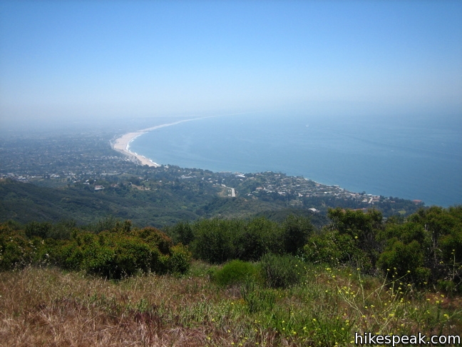
Parker Mesa Overlook is one of the best vista points in the Santa Monica Mountains, serving up panoramic views over Santa Monica Bay from a 1,525-foot oceanfront ridge in Topanga State Park. The overlook is located along East Topanga Fire Road, a north-south running ridge trail spanning between Trippet Ranch, the park’s main trailhead in the north, and Paseo Miramar in the Pacific Palisades to the south. From Trippet Ranch to Parker Mesa Overlook is a 6.7-mile round trip hike with 375 feet of elevation change.
As an alternative, you may begin your hike from Paseo Miramar for a 5.7-mile round trip hike starting from the south end of East Topanga Fire Road. If you set out from Los Liones Canyon, just below the ridge, it is a 7.8-mile round trip hike to Parker Mesa Ovelrook.
Starting from Trippet Ranch, the directions are straightforward. Begin up the wide fire road departing from the south end of the parking lot next to the sign labeled “Trippet Ranch Trailhead.” Follow the connection trail as it turns right then left up a grassy slope spotted with oaks. After a quarter mile, you will come to an important T-junction. To the left, Eagle Springs Fire Road heads northeast toward Eagle Rock and Temescal Ridge. To the right, East Topanga Fire Road heads southwest toward Parker Mesa Overlook.

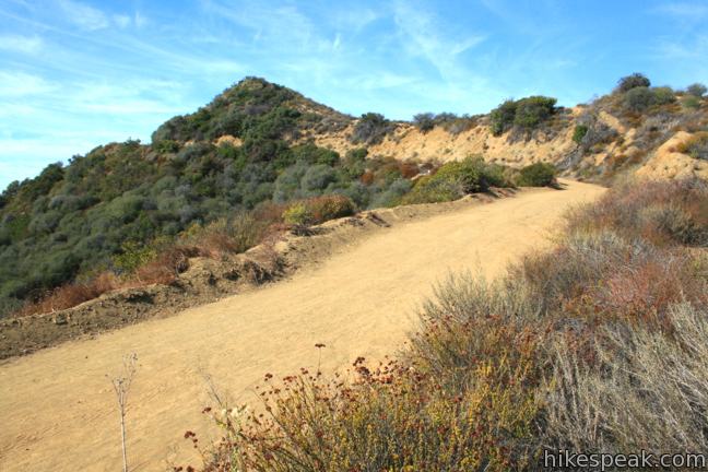
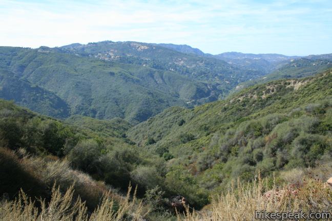
Turn right up the wide and well-maintained trail, which leaves the oaks for sagebrush along the undulating ridge. As you cross the ridge-top, you will be surrounded by broad views into deep canyons. To the left is Santa Ynez Canyon, stretching south into the Pacific Palisades. To the right is enchanting Topanga Canyon, a thousand foot trench cutting across the range.

It is an up and down adventure on this sun-exposed trail. You will climb 100 feet, drop 50 feet, climb 175 feet, drop 200 feet, climb 250 feet… and finally arrive at the spur trail leading to Parker Mesa Overlook, 2.9 scenic miles from the start. Turn right and hike the final 0.55 miles over rolling terrain to the overlook at the end of the mesa.
From an elevation of 1,525 feet, Parker Mesa Overlook provides a grand perch over the Santa Monica Mountains and the Pacific Ocean spread out below. A pair of benches allow you to rest your legs while you enjoy the expansive view over Santa Monica Bay to the south. Palos Verdes Peninsula juts out from the far side of the C-shaped bay. Beyond that, on a clear day, you will spot Catalina Island on the horizon.
Parker Mesa Overlook can also deliver a mesmerizing sunset. Pack a flashlight for the hike back if you plan to stay that late. Also be sure to leave your vehicle outside Topanga State Park. Trippet Ranch closes at sunset, so park along the road outside the gate and walk in. Mountain bikes are welcome but dogs are not allowed.

To get to the trailhead: From PCH, take Topanga Canyon Road inland for 4.6 miles to Entrada Road. Alternately, from the 101 Freeway, drive 7.7 miles south on Topanga Canyon Road to reach Entrada Road. Turn east on Entrada Road and drive up the mountain for one mile, following signs for Topanga State Park. There is a $10 day-use fee to park at Trippet Ranch (price as of 2018), which is open from 8:00 a.m. to sunset. Free parking is available along the road just outside the park.
Trailhead address: 20829 Entrada Road, Topanga Canyon, CA 90290
Trailhead coordinates: 34.0933, -118.5874 (34° 05′ 35.87″N 118° 35′ 14.64″W)
You may also view a regional map of surrounding Los Angeles trails and campgrounds.
 | Parker Mesa Overlook from Paseo Miramar This steep out-and-back hike visits Parker Mesa Overlook from the opposite direction, delivering more knockout views. |
 | Eagle Rock from Trippet Ranch This 4.5-mile loop takes Musch Trail and Eagle Springs Fire Road to visit an exceptional sandstone summit in Topanga State Park. |
 | Eagle Rock from Santa Ynez Canyon This 7.4-mile hike takes the long route from a canyon in the Pacific Palisades up to the panoramic sandstone summit. |
 | Los Liones Trail This hike visits a lust canyon with ocean views, a potential start of the hike to Parker Mesa Overlook. |
 | Santa Ynez Falls This 2.5-mile follows a shaded creek to a gorge containing a short waterfall. |
 | Viewridge Trail This 3-mile hike in Summit Valley Edmund D. Edelman Park travels down a canyon on Viewridge Trail (also known Santa Maria Canyon Trail) to Summer Hill Ranch Road where there are sweeping views over Topanga and the Santa Monica Mountains from Canyon Overlook. |
 | Hondo Canyon This section of the Backbone Trail crosses fields of grains and forests of bays, climbing 1,550 feet over 3.8 miles to a small ocean view. Extend the hike to Topanga Lookout for an incredible perspective over the Santa Monica Mountains. |
 | Tuna Canyon Park This 1.6 to 5.1-mile hike offers spectacular ocean views from a less-visited park between Topanga and Malibu. |
 | More trails in the Santa Monica Mountains Explore other destinations in the range. |
 | La Jolla Canyon Loop This 11.75-mile hike explores Point Mugu State Park on the west end of the Santa Monica Mountains, offering extraordinary ocean views. |
 | Calabasas Peak This 3.6-mile hike travels an easy-to-follow fire road, climbing 900 feet to panoramic views of the Santa Monica Mountains and San Fernando Valley. |
 | Zuma Ridge Trail This wide dirt service road which weaves northwest up the back of the ridge west of Zuma Canyon offering access to several trails in the area. |
 | Sandstone Peak This 6.25-mile loop summits the tallest peak in the Santa Monica Mountains. |


This is a phenomenal hike with amazing views of the Santa Monica Bay. I strongly suggest starting at Los Liones Canyon as the first 1.5 miles on the trail are narrow and lush and completely different terrrain (great for running) that the rest of the hike which is basically dirt fire road.
Excellent directions and information on this site!
[…] have a way home and enough time to seek the eight geocaches on that stretch of the trail! (Click here for a description of the whole fire road trail if you’re curious about […]
[…] More information: Trip description here […]
Somewhere I read that this was a good beginner trail for mountain bikers. Maybe if you are already in killer shape. VERY steep to be riding up on a bike. Nearly every hiker looked at us with sympathy. Great views, tough climb.
Regularly ride 30 miles/week on flat cement (beach bike path) and today decided to ride 75% of this route. OMG it kicked my ass for 45 minutes. Now humbled, and needing a jacuzzi. Parker Mesa Overlook trail: I will see you again.
Those are really amazing views! We have some pretty amazing views here in Arizona as well. It’s really something how wonderful nature is. So beautiful and calming. There’s nothing else like it. Everyone should take time out and just experience what mother nature has just waiting to be discovered.