Of all the Morros in San Luis Obispo County, Black Hill is the easiest to summit (even easier than Islay Hill. This 661-foot volcanic peak in Morro Bay State Park can be reached by hiking 0.6 miles round trip up a dirt single track with 190 feet of elevation gain and views over the city of Morro Bay. For those looking for more, there are longer hikes to the summit starting farther down Black Hill.
For a short hike: Start from a trailhead parking area in Morro Bay State Park just up the hillside from Morro Bay Golf Course. As you begin up the dirt trail, you will come to an immediate junction. To the right, Black Hill Trail angles along a water tower, before dropping down the hill. This route is used by those opting for a longer hike. To reach the summit, turn left, heading uphill on Black Hill Trail. There are no other junctions on the trail to the top.

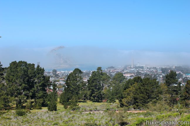
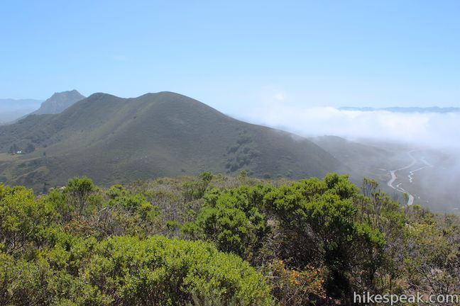
After a few switchbacks beneath Monterey pines, the trail reaches sage-covered slopes with open views. You will be treated to sights of Morro Bay and Morro Rock, an iconic 578-foot tall pyramid-shaped peak that rises above the beach. Morro Rock is the westernmost of San Luis Obispo Country’s Morros, also called The Nine Sisters, a string of volcanic plugs that run from Morro Bay to Edna Valley. Not all of the Morros are open to the public. Black Hill is the westernmost Morro that you can summit. Also open for hiking is Islay Hill, the last Morro to the east in Edna Valley. The two tallest Morros, located near downtown San Luis Obispo, can also be hiked, Bishop Peak and Cerro San Luis. The only other Morro that is open for hiking is Cerro Cabrillo, also in Morro Bay State Park, which you will see from the summit of Black Hill because it is the next Morro to the east.
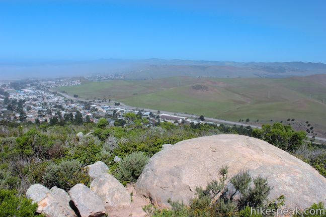
Continue up the sage-lined trail past pockets of sticky monkeyflower that bloom in the spring to reach the boulder-covered summit of Black Hill, 0.3 miles from the start. The trail ends at the top, where it splinters to explore different outcroppings that each present a slightly different view.

To the south are views across the natural network of canals in the estuary on the east side of Morro Bay, which flood and reemerge with the tides. Beyond the bay, the Irish Hills form a wall to the south, capped by the summits in Montaña de Oro State Park at the ocean end of the range. Cerro Cabrillo rises to the southeast, with a long jagged summit ridge that can be reached via an off-trail hike. Highway One passes below the east and north sides of Black Hill and the foothills of the Santa Lucia Mountains are visible to the east and north. The most alluring angle of the summit 360 is probably to the west, where Morro Rock rises above the Pacific.

Stick with the worn paths on the summit as there are a few hidden patches of poison oak. When you have fully explored the view, return the way you came.
For a longer hike: You could choose to set out from a number of places below Black Hill. If you are staying at the campground in Morro Bay State Park (140 sites) you can hike from the campground to the summit via a lower section of Black Hill Trail or a combination of Exercise Trail and Grove Trail. Both single tracks, Grove Trail and Black Hill Trail, cross Park View Road where non-camping hikers can hop on either trail.
One option, for a 1.9-mile out and back hike with 625 feet of elevation gain, is to begin up Grove Trail from the intersection of Park View Road and State Park Road. Find the unmarked and unpronounced dirt trail on the northwest side of the intersection and begin hiking up a field and through a grove of eucalyptus trees. After just over a quarter mile you will come to an unmarked junction with Black Hill Trail. The section of the trail leading down to Park View Road splits off to the left, looking even less-traveled than Grove Trail. Straight ahead, Black Hill Trail continues up Black Hill. Take it past a few more unmarked junction.
Head straight though an intersection with Pipeline Trail, followed quickly by yet another junction. When you come to a wooden gate at a T in the trail, a third of a mile from the start, turn right to continue up Black Hill Trail. Almost instantly, the forest changes from eucalyptus to oaks. Stay to the right through one more junction and hike up through the oak grove along a draw in the mountainside. Slip through a few additional wooden bike gates before circling around the water tank to meet up with the shorter route to Black Hill, just above the upper trailhead.
Any hike up Black Hill Trail is bound to be a pleasant one. Dogs and mountain bikes are allowed on these trails. No fee or permit is required to hike to the summit of Black Hill, so get out and enjoy!
To get to the trailhead: From Highway 1 in Morro Bay, take exit 277, following signs for Los Osos and Baywood Park. Turn south on South Bay Boulevard, drive 0.7 miles to State Park Road, and turn right. Go a tenth of a mile to Park View Drive and turn right (this is the trailhead for the Grove Trail). Drive 0.6 miles, entering Morro Bay Golf Course, and turn right at the first junction up the unsigned Black Hill Road. Proceed 0.8 miles up Black Hill to the trailhead at road’s end.
Trailhead address: Black Hill Road, Morro Bay, CA 93442
Trailhead coordinates: 35.35806, -120.83338 (35° 21′ 29″N 120° 50′ 00.17″W)
You may also view a regional map of surrounding Central Coast trails and campgrounds.
 | Morro Rock via Morro Strand Trail This level one to 3.5-mile round trip hike starts from Cloisters Park and crosses Morro Strand State Beach to reach Morro Rock. |
 | Cerro Cabrillo This tough 2.5-mile hike summits the highest mountain in Morro Bay State Park, a 911-foot member of the Nine Sisters. |
 | Turtle Rock This easy 2.1-mile hike reaches a short rise between Black Hill and Cerro Cabrillo in Morro Bay State Park. |
 | Portola Point This 2-mile loop explores a short hill just east of Morro Estuary in Morro Bay State Park. |
 | Chumash & Crespi Trails Loop This 2.9-mile circuit in Morro Bay State Park visits an oak grove and bay views by combining Chumash Trail, Crespi Trail, and Hutash Trail. |
 | Elfin Forest Natural Reserve This easy 1-mile loop on a boardwalk explores a pygmy forest on the edge of Morro Bay. |
 | Morro Dunes Ecological Reserve This 2.6-mile loop serves up panoramic views over Morro Bay as it ascends 800 feet from Los Osos to Montaña de Oro State Park. |
 | More hikes in San Luis Obispo Explore other trails around San Luis Obispo including Montaña de Oro State Park and the Morros. |


We parked our car at the California State Park headquarters and began the grove hike connecting to the Black Hill hike. The headquarters are located near the intersection of Park View Drive and State Park Drive. The grove trail was dry dirt today. but could become very muddy and slippery when it becomes wet. The grove trail is well pronounced, but not maintained as well as the Black Hill Trail. We saw a number of people using the trail. The trail was being used by campers staying at Morro Bay State Park where there is a trail head to the Black Hill Hike and residence of Morro Bay using the trail as a workout. People were very friendly and everyone was having a good time. The summit of Black Hill provides unrestricted views of Morro Bay, Morro Rock, and the surrounding area Try and go when the fog is not in. At times it can hide Morro Rock. This short hike is a must if you are camping, and an attraction to people who live out of the area. It may be short, especially if you drive to the upper trail head, but the hike is well worth your time and effort.
[…] you’d rather stay on dry land, hike Black Hill. This trek up one of the Nine Sisters offers another perspective on the estuary and gives you two […]
[…] The hike up Black Hill, one of the Nine Sisters, is a local favorite. It offers a birds’ eye view of the estuary and the watershed, and you can choose whether to do a longer hike of about 3 miles round-trip, or a shorter version of only .6 miles. […]
This is a great trail but can be confusing at intersections, it is a climb but its good for kids as they can have satisfaction when making it to the top without to much trouble. The trail might be hard for kids 5 and under.
[…] Morro Bay State Park, the second peak is Black Hill (665 feet / 203 m). This sister is the easiest hike (0.6 mi roundtrip) to reach a worthwhile vista, […]
[…] you’d rather stay on dry land, hike Black Hill. This trek up one of the Nine Sisters offers another perspective on the estuary and gives you two […]
Horrible, horrible directions. Had to turn around several times due to the poor directions, never got to the trailhead. Someone with some sense of direction please update this article.
[…] hikes can start in downtown! We started in downtown,headed toward the golf course and accessed the Black Hill Trail. After enjoying the view for a bit we came down and walked along the road near the shore and […]
[…] climb up Morro Rock, you can hike to the top of 5 of the other inactive volcanic Morros nearby: Black Hill, Cerro Cabrillo, Bishop Peak, Cerro San Luis, and Islay […]
[…] jump into the car and drive to Black Hill, part of Morro Bay State Park, which is just up beyond the Golf Course. Here you’ll get your best overhead view of Morro […]