![]()
Located in the southeast corner of Griffith Park, Beacon Hill is the easternmost summit in the Santa Monica Mountain Range. The 1,001-foot hill towers over the Los Angeles River and provides panoramic views from Burbank to Santa Monica Bay. On a clear day, Beacon Hill issues a stunning panorama. The summit can be reached via a 2.75-mile out and back hike, or a 3.9-mile loop, both with 500 feet of elevation change.
Start from the merry-go-round parking area on the east side of Griffith Park and head up Fern Canyon Trail. To reach this fire road, walk up the paved road beyond the barriers that direct traffic into the parking lot. Turn left up the third dirt trail breaking off from the road, just in front of a second row of barricades.
Hike up Fern Canyon Trail, staying to the left through two junction in the first tenth of a mile with trails breaking off toward the Old Zoo Picnic Area and Bee Rock. After another tenth of a mile, continue past a path on the left dropping down to Fern Canyon Amphitheater.

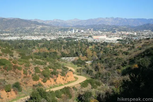
Fern Canyon Trail tapers out as it weaves around four creases in the mountainside. Views to the east over Griffith Park, Glendale, and the mountains beyond continuously expand all the way to a 5-way junction, 1.15 miles from the start. Take the only trail to the left, and hike another 0.2 miles across a saddle up to the top of Beacon Hill.
Back in the early decades of the 1900s, and long before the days of LAX, the Grand Central Airport in Glendale was the main airport for Los Angeles. A luminous beacon was placed on this hill to warn pilots of the mountains rising to the west. All evidence of the beacon has disappeared from the hill, except for the name.

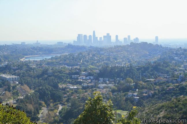
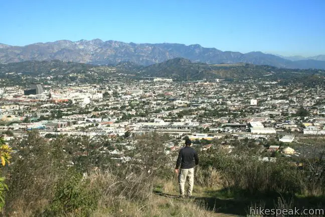
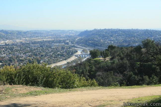
The quality of the view from this low summit on a clear day is quite surprising. To the south, just a few miles away, is the skyline of downtown Los Angeles. Before that, Silver Lake Reservoir, the 5 Freeway, and the Los Angeles River are all in sight. To the west, Santa Monica Bay offers a glistening ocean wink. On the clearest of days following a rainstorm, barges can even be spotted on the Pacific. To the west and northwest are the higher summits of Griffith Park, Mount Hollywood and Mount Bell. To the north and east are the cities of Glendale, Eagle Rock, and Burbank, framed by the Verdugo Mountains and the San Gabriel Mountains, which rise above the urban landscape. Even Mount Baldy is visible from Beacon Hill. It is quite a sight!

After absorbing the vista, return to the 5-way junction. Turn right to return the way you came for a 2.75-mile out and back hike, or turn left to loop back to the trailhead via Coolidge Trail. The roads straight across from Beacon Hill can be use to explore farther westward into the park, adding a one-mile loop or more.

To continue the loop, turn left down Coolidge Trail, which delivers a closer view of downtown Los Angeles as well as a good over-the-shoulder perspective of Beacon Hill. Wrap down the mountainside and around a canyon progressing southward for one mile, descending 375 feet to a tall metal fence at the top of the driving range belonging to the Tregnan Golf Academy in Griffith Park.
Just beyond the fence, the trail splits. Stay to the left angling uphill and northward around the skirt of Beacon Hill on Lower Beacon Trail. This trail will take you 1.25 miles back to the trailhead, giving you a closer view of I-5 along with an earful of traffic. As you pass beneath the eastern slope of Beacon Hill, the trail launches into a sudden climb, picking up 100 feet as the trail seems to shout, “I’m not through with you yet!” After surprising rise, you will head downhill for 0.4 miles to the trailhead directly across from the merry-go-round parking lot, completing the loop.
There is no fee or permit required to hike to Beacon Hill in Griffith Park. Whichever route you choose, this is a short hike with the potential for sweeping views. Dogs are welcome on a leash. No bikes. The trailhead is only a five-minute drive from downtown Los Angeles, so get out and enjoy!
To get to the trailhead: Take the 5 Freeway to the Los Feliz Boulevard exit. Drive west on Los Feliz Blvd. to the first light and turn north on Crystal Springs Road. Drive north for 1.3 miles and turn left at the intersection following signs for the merry-go-round. Drive up the hill for a quarter mile and turn right at the barricade in the road into the parking lot. Begin hiking up the barricaded road, which curves to the right toward Fern Canyon.
Trailhead address: Crystal Springs Drive & Fire Road, Griffith Park, Los Angeles, CA 90027
Trailhead coordinates: 34.131, -118.284 (34° 07′ 51.6″N 118° 17′ 02.4″W)
View Griffith Park in a larger map
Or view a regional map of surrounding Los Angeles trails and campgrounds.
 | Old Zoo Picnic Area This half-mile hike explores the abandoned exhibits and animal cages in the ruins of the old LA Zoo in Griffith Park. |
 | Bee Rock This hive-shaped point on the east side of Griffith Park is reached via a 1.7 to 4-mile round trip hike. |
 | Amir's Garden This one-mile hike reaches a relaxing garden on the east side of Griffith Park that is a pleasant retreat for hikers. |
 | Cedar Grove & Vista View Point Loop This 2.3-mile loop on the southeast side of Griffith Park follows paved and unpaved trails to two park attractions, a quiet grove with a picnic area and a helipad with panoramic views. |
 | Glendale Peak This hike is around three miles long and visits a less known summit on the southeast side of Griffith Park with views that deserve more attention. |
 | Glendale Peak - Mount Hollywood Loop This 4.15-mile hike tops two summits in Griffith Park that both have awesome views. |
 | Mount Hollywood This 1,625-foot peak is a star of Griffith Park with panoramic views that can be reached from Griffith Observatory on a steep 1.4-mile hike or a scenic 2.65-mile trek and from lower in the park in Western Canyon for a hike of around 4.2 miles. |
 | Griffith Observatory via East Observatory Trail This 1.5-mile hike from Vermont Canyon Avenue up to Griffith Park's great observatory delivers excellent views over Los Angeles along the way. |
 | Griffith Observatory via West Observatory Trail This 2.1-mile hike ascends from Western Canyon up ridges to Griffith Observatory, getting sweeping views over Los Angeles and Griffith Park along the way. |
 | Ferndell Trail This relaxing half-mile hike goes through a tropical garden in the lushest little canyon in Griffith Park. Explore farther on a 1.75-mile hike in Western Canyon or venture up to the Griffith Observatory to see more of the park. |
 | Mount Chapel, Mount Bell, and Mount Hollywood This 5.7-mile loop tops three prominent summits on a panoramic tour of Griffith Park. |
 | Bronson Cave This short easy hike visits a man-made cave recognizable as the Batcave from the 1960s Batman TV series and hundreds of other locations on TV and film. |
 | Mount Lee and the Hollywood Sign via Hollyridge Trail This 3.5-mile hike ascends 750 feet to reach the summit of Mount Lee behind the Hollywood Sign. |
 | Mount Lee and the Hollywood Sign via Brush Canyon Trail This 6.4-mile hike crosses Griffith Park from Canyon Drive to the top of Mount Lee directly behind the landmark Hollywood Sign. |
 | Hollywood Sign via Innsdale Drive, Mulholland Highway, and Mount Lee Drive This 4.6-mile round trip hike combines trails and streets to deliver some of the very best views of the Hollywood Sign on the way to the summit of Mount Lee above the sign. |
 | Cahuenga Peak This 3-mile hike on Burbank Peak Trail and Aileen Getty Ridge Trail ascends to Cahuenga Peak and the adjacent Mount Lee, home of the Hollywood Sign. |
 | Lake Hollywood Reservoir Walking Trail This 3.5-mile loop circles a peaceful fence-enclosed reservoir in the hills below the Hollywood Sign. |
 | More trails in the Santa Monica Mountains Explore other destinations in the range. |
I hiked this in March. This is a good hike (in my opinion) if you are going to hike alone (I did). There were lots of woodpeckers out on the dead trees near the trail when I hiked this in March. There are some nice rock bedding layers near the saddle before you get to the top. The trail can be slippy in places, so a walking stick and/or well treaded shoes/boots are helpful (but not necessary). This is a good quick hike if you’ve only got an hour to spend (the out and back route).
Well said. Glad you enjoyed the hike!
Griffith Park hiking question. If you were facing Griffith Park from I-5, and look up towards the right you can see a rock formation jutting out. Also visible is some metal or fencing at the top. Is this the top of Beacon Hill? It has been many years since I have hiked it and just want to remember. Thanks, Jim
Close! That’s actually Bee Rock. You can get there from the Old Zoo, which is worth checking out too.
If you look closely, there is a metal stub of the beacon still poking out of the ground on the summit of Beacon Hill.
… [Trackback]
[…] Informations on that Topic: hikespeak.com/trails/beacon-hill-hike-griffith-park/ […]