-
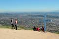
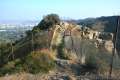
"M" Trail in San Luis Obispo
This spur off the trail up Cerro San Luis leads to a large white "M" installed halfway up the east side of the mountain.
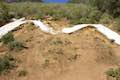
1.9 miles
560 feet
Open to hikers, dogs, bikes
-
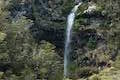
Akaka Falls in Akaka Falls State Park
This short loop slips through a tropical valley to bold views of a 442-foot single-drop waterfall.
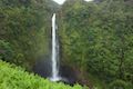
0.55 miles
115 feet
Open to hikers
-
Alcove Nature Trail in Colorado National Monument
This out and back hike is less scenic than others in the park but offers information about the plants, animals, and geology of the park.
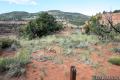
1 miles
175 feet
Open to hikers
-
Alder Island Nature Trail in Lincoln City
This short, easy hike off the coast south of Lincoln City explores a small island at the mouth of the Siletz River.
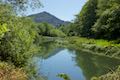
0.85 miles
5 feet
Open to hikers
-
Amboy Crater in Amboy
This out and back hike travels up and into a volcanic crater near Mojave National Preserve.
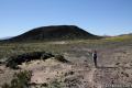
3 miles
275 feet
Open to hikers, bikes
-
Amir's Garden in Griffith Park
This out and back hike reaches a relaxing garden on the east side of Griffith Park that is a pleasant retreat for hikers.

1 miles
275 feet
Open to hikers, dogs
-
Angel Vista via Rosewood Trail in Thousand Oaks
This out and back hike is the most direct route to a panoramic viewpoint overlooking the Conejo Valley.

4 miles
850 feet
Open to hikers, dogs, bikes
-
Angel Vista via West Los Robles Trail in Thousand Oaks
This out and back hike offers a more gradual route to the overlook on the north side of the Santa Monica Mountains.
7.6 miles
800 feet
Open to hikers, dogs, bikes
-
Angel's Rest Trail in Columbia River Gorge
This hike ascends to a panoramic landing with spectacular views across the gorge (particularly at sunrise).
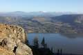
4.8 miles
1500 feet
Open to hikers, dogs
-
Angels Landing in Zion National Park
This out and back hike ascends a sandstone tower that juts into Zion Canyon. The amazing views and thousand foot drop-offs have made this trail world famous.
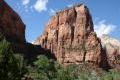
5.2 miles
1500 feet
Open to hikers
-
Anza Loop Trail in Calabasas
This hike follows a historic route through rolling hills in Calabasas south of the 101 Freeway.

4.5 miles
535 feet
Open to hikers, dogs
-
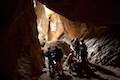
Ape Cave Lava Tube in Mount Saint Helens National Volcanic Monument
This adventurous underground hike travels through one of the longest lava tubes in the world.
3.75 miles
400 feet
Open to hikers
-
Apsley Waterhole & Lookout Track in Douglas-Apsley National Park
This loop travels through a eucalyptus forest to a popular swimming hole on the Apsley River in Douglas-Apsley National Park.

0.9 miles
100 feet
Open to hikers
-
Arch Rock in Joshua Tree National Park
This easy loop visits a natural arch in the granite formations around White Tank Campground.

1.3 miles
100 feet
Open to hikers
-
Archie Briggs Canyon Trail in Bend
This short hike descends a ravine to clifftop views over a dramatic canyon on the Deschutes River.
1.25 miles
325 feet
Open to hikers, dogs, bikes
-
Arroyo Sequit in Santa Monica Mountains
This winding loop explores the upper reaches of a canyon carved by the East Fork of Arroyo Sequit and has grand views of the Santa Monica Mountains.
2.05 miles
285 feet
Open to hikers, dogs, bikes
-
Arthur's Pass Village to Bridal Veil Falls Lookout in Arthur's Pass National Park
This hike up Arthur's Pass Walking Track takes a gradual approach to a viewpoint with a perspective of Bridal Veil Falls and surrounding mountains.
1.1 miles
225 feet
Open to hikers
-
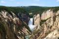
Artist Point in Yellowstone National Park
This viewpoint delivers one of the most photographed views in Yellowstone, a memorable perspective of the 308-foot Lower Falls.
0.2 miles
50 feet
Open to hikers
-
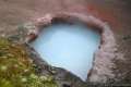
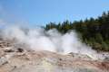
Artists' Paintpot in Yellowstone National Park
This hike circles a hillside hydrothermal area, passing bursting mudpots, bubbling hot springs, and mesmerizing milky blue pools.
1.1 miles
125 feet
Open to hikers
-
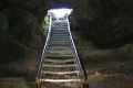
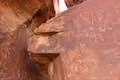
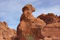
Atlatl Rock in Valley of Fire State Park
Step right up a flight of stairs to a platform in front of a group of petroglyphs on the side of a boulder.
0.1 miles
50 feet
Open to hikers, dogs
-
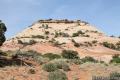
Aztec Butte in Canyonlands National Park
This lollipop loop hike ascends a dome-shaped butte that boasts Puebloan granaries and a nice view of Taylor Canyon.
1.8 miles
250 feet
Open to hikers
-
Azusa Peak and Glendora Peak in Azusa
This 2 2/3-mile or 4 2/3-mile out and back hike ascends Garcia Trail to "the A" and one or two picturesque summits along Glendora Ridge Motorway.
4.65 miles
1800 feet
Open to hikers, dogs, bikes
-
Back Basin of Norris Geyser Basin in Yellowstone National Park
This loop passes Steamboat Spring, the world's largest geyser, and several other hydrothermal features.
1.75 miles
100 feet
Open to hikers
-
Badlands Loop in Death Valley National Park
This loop offers a great immersion into the terrain beneath Zabriskie Point.

2.5 miles
300 feet
Open to hikers
-
Badwater Basin in Death Valley National Park
This is the lowest place in North America -- a required stop for first time visitors to Death Valley.

1 miles
10 feet
Open to hikers
-
Bailey Cove Trail in Shasta Lake
This easy loop circles a hill-covered peninsula on the McCloud Arm of Shasta Lake, providing both lake views and shade.

3.1 miles
50 feet
Open to hikers, dogs, bikes
-
Bajada Trail in Joshua Tree National Park
This level nature trail loop explores the plants living on a desert bajada.
0.3 miles
5 feet
Open to hikers
-
Balanced Rock in Arches National Park
This short loop circles a perilous block of sandstone balancing near the center of Arches National Park.
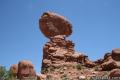
0.33 miles
50 feet
Open to hikers
-
Balancing Rock in Valley of Fire State Park
This brief hike, which begins next to the park visitor center, approaches a rock formation that appears to stand with a bit of magic.
0.25 miles
10 feet
Open to hikers, dogs
-
Balconies Cave in Pinnacles National Park
This fun hike venture down Balconies Trail past impressive rock formations and through an exciting talus cave.
2 miles
200 feet
Open to hikers
-
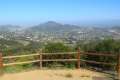
Baldwin Hills Scenic Overlook in Culver City
This up and back hike ascends a dirt trail or a steep staircase to an expansive view over the Los Angeles Basin.
2.5 miles
315 feet
Open to hikers
-
Baldy Notch in Angeles National Forest
To hike the scenic Devil's Backbone to Mount Baldy, you must pass through Baldy Notch. You can hike to the notch, or take a ski lift.
11.3 miles
1500 feet
Open to hikers, dogs, bikes
-
Barker Dam in Joshua Tree National Park
This level loop visits a small foreign-looking reservoir within the Wonderland of Rocks.
1.5 miles
50 feet
Open to hikers
-
Beacon Hill in Griffith Park
This out and back or loop hike climbs to the easternmost summit in the Santa Monica Mountains.
3.9 miles
500 feet
Open to hikers, dogs
-
Beacon Rock Trail in Beacon Rock State Park
This hike takes an impressively engineered trail packed with switchbacks that scale a monolith along the Columbia River.
1.6 miles
600 feet
Open to hikers, dogs
-
Bealey Chasm Walk in Arthur's Pass National Park
This short walk passes through moss-covered beech trees to a bridge over Bealey River where it slips through a ravine.
0.4 miles
40 feet
Open to hikers
-
Bear Gulch Reservoir via Bear Gulch Cave Trail & Moses Spring Trail in Pinnacles National Park
This out and back hike passes through a talus cave to reach a boulder-cradled reservoir.
1.5 miles
275 feet
Open to hikers
-
Beaver Falls in Clatskanie
This short hike slips down through forest to a beautiful waterfall plunging over a basalt wall.
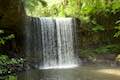
0.7 miles
100 feet
Open to hikers, dogs
-
Bee Rock in Griffith Park
This loop reaches a bee hive-shaped point on the east side of Griffith Park.
2.6 miles
600 feet
Open to hikers, dogs
-
Beetle Rock in Sequoia National Park
This short walk from the Giant Forest Museum to Beetle Rock visits a granite dome with great views and stunning sunsets.
0.25 miles
50 feet
Open to hikers
-
Benham Falls in Deschutes National Forest
This leisurely hike on Deschutes River Trail gathers views of aggressive cascades on a churning and tumbling stretch of the Deschutes River.
1.9 miles
50 feet
Open to hikers, dogs, bikes
-
Big Ed Tree Trail in Sierra National Forest
This hike is quite short, but visits a tree that is quite big - part of the Nelder Grove of Giant Sequoias in Sierra National Forest.
0.2 miles
25 feet
Open to hikers, dogs
-
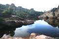
Big Spring via Tubb Canyon Trail in Anza-Borrego Desert State Park
This out and back hike follows a footpath across Tubb Canyon to Big Spring in a desert canyon below Pinyon Ridge in the San Ysidro Mountains.
1.5 miles
200 feet
Open to hikers
-
Big Sur River Gorge in Big Sur
This off-trail hike ventures up the Big Sur River on a water-wading boulder-hopping adventure to a crystal clear pool that's a gorgeous Big Sur swimming hole.

0.5 miles
50 feet
Open to hikers
-
Big Trees Trail in Sequoia National Park
This loop explores giant sequoias around Round Meadow on a paved nature trail that is easy, educational, and beautiful.
1.4 miles
50 feet
Open to hikers
-
Biscuit Basin in Yellowstone National Park
This loop explores hydrothermal features in Upper Geyser Basin like Black Opal Pool, Sapphire Pool, and Black Pearl Geyser.

0.65 miles
50 feet
Open to hikers
-
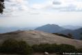
Bishop Peak in San Luis Obispo
This out and back hike summits the tallest of the Nine Sisters for excellent views over San Luis Obispo.

3.5 miles
950 feet
Open to hikers, dogs
-
Black Butte in Deschutes National Forest
The hike summits one of the most identifiable peaks in Central Oregon, which has fire lookout towers and panoramic views of the Cascade Mountains.
4 miles
1550 feet
Open to hikers, dogs
-
Black Hill in Morro Bay State Park
This out and back hike to the summit of one of San Luis Obispo County's Nine Sisters reaches 360-degree views over Morro Bay.
0.6 miles
190 feet
Open to hikers, dogs, bikes
-
Blowhole & Fossil Bay Lookout in Tasman National Park
This short walk reaches a coastal vista point and a wave-carved tunnel through a rocky point that has the potential to spray up like a whale spout.
0.3 miles
30 feet
Open to hikers
Moraine Trail to Fallen Leaf Lake
in Lake Tahoe Basin National Forest Lands
Lake Tahoe | Trails Trail Rating:
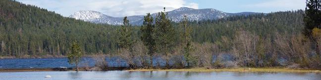
What's better than hiking by a lovely creek - maybe hiking by a lovely lake. You can do both on Moraine Trail, visiting Fallen Leaf Lake and Taylor Creek in the Lake Tahoe Basin National Forest Lands near South Lake Tahoe. This easy and level loop is 1.1 miles long, including a short side trail to Fallen Leaf Lake Dam. The mountain-cradled Fallen Leaf Lake is located just south of Lake Tahoe. ...Read more.
By: Published: July 26, 2023 Last updated: July 1, 2025