Mount Baldy Sierra Club Ski Hut Trail Mount Baldy hike San Gabriel Mountains
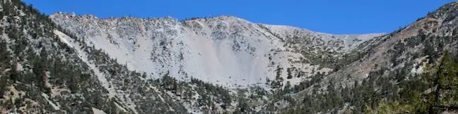
Baldy Bowl - Ski Hut Trail climbs 3,900 feet over 4.5 miles to the highest summit in the San Gabriel Mountains. The trails ascends the southwest side of the mountain and is the shortest route to the top that does not involve the use of a ski lift. Expect an aggressive climb for most of the hike rewarded by views over San Antonio Canyon. Halfway up the mountain, the trail passes a Sierra Club... Read more.
By: Published: Last updated: April 28, 2017
San Antonio Falls beneath Mount Baldy San gabriel Mountains Waterfall hike
San Antonio is a 75-foot tall multi-tier year-round waterfall carrying water off Mount Baldy. The waterfall swells in late winter and early spring when snow melt increases the flow. The toughest thing about getting to San Antonio Falls isn't the hike, it's the long drive to the base of Mount Baldy. The hike to San Antonio Falls is easy. Simply march 0.6 miles up a paved road to a dirt... Read more.
By: Published: Last updated: June 11, 2019
Morro Dunes Ecological Reserve Bayview Loop Trail Los Osos Hike San Luis Obispo Montana de Oro California
The community of Los Osos on the San Luis Obispo County coast is buffered on the south side by an ecological reserve. A 2.6-mile hike through Morro Dunes Ecological Reserve (also called Bayview Ecological Reserve) ascends 800 feet, briefly entering Montaña de Oro State Park at the trail's highest point. The loop travels over ancient sand dunes that became grown over by grasses and brush. ... Read more.
By: Published: Last updated: May 11, 2017
El Moro Elfin Forest Natural Preserve hike boardwalk overlooking Morro Bay Estuary Los Osos Elfin Forest
Elfin Forest Natural Preserve (also know as Los Osos Elfin Forest and El Moro Elfin Forest Natural Area) lies between the communities of Morro Bay and Los Osos on the coast of San Luis Obispo County. A mile of boardwalk circles the 90-acre preserve, providing opportunities to gaze across Morro Bay and admire nearby peaks in Morro Bay State Park. There is a thin 80 feet of elevation gain... Read more.
By: Published: Last updated: May 20, 2017
Gaviota State Park Tunnel View Trail Trespass Trail Loop Santa Barbara hike California Highway 101
On Tunnel View Trail, you can expect to see exactly what the name advertises, a view of the Gaviota Tunnel crossed by northbound traffic on Highway 101 between Santa Barbara and Buellton. You can also expect this 2.6 mile loop with 600 feet of elevation gain to deliver a rustic hiking experience up a narrow overgrown trail. If you could tune out the din of the freeway below, the trail would... Read more.
OK! Add to trails I’ve hiked
OK! Add to trails I want to hike
Tagged with · California State Parks · Gaviota State Park · Goleta · Santa Ynez Mountains
Distance: 2.6 miles · Elevation change: 600 feet
By: Published: Last updated: May 20, 2017
Scenic and Overlook Trails Loop Point Mugu State Park Malibu Los Angeles California hiking trail Big Sycamore Canyon
Point Mugu State Park preserves a stunningly picturesque portion of the Santa Monica Mountains at the west end of Malibu. When you see park trails with names like Scenic Trail and Overlook Trail, you anticipate first class ocean views. Scenic and Overlook Trails Loop delivers the goods! This 2.7-mile hike climbs 425 feet to tremendous vistas atop a ridge west of Big Sycamore Canyon. The... Read more.
By: Published: Last updated: May 19, 2024
Tuna Canyon Park Santa Monica Mountains Conservency Malibu Topanga California hiking trail Big Rock Lateral Hearst Tank Motorway Pacific Ocean view
Tuna Canyon Park preserves 1,255 beautiful acres in the mountains between Topanga and Malibu. Despite being relatively unknown and under-visited, the park delivers some of the grandest ocean views to be found anywhere in the Santa Monica Mountains. From ridges 1,500 feet above a silken Pacific Ocean, Tuna Canyon Park looks east toward Santa Monica Bay and west up the coast of Malibu. ... Read more.
By: Published: Last updated: December 7, 2018
Indiana Dunes National Lakeshore Dune Succession Trail West Beach hike beach Lake Michigan
Dune Succession Trail in the West Beach area of Indiana Dunes National Park offers a mile-long look at the stages of dune development, starting with a beach on the shore of Lake Michigan and ending with a boardwalk through a forest that has risen from the sand. The loop has 100 feet of elevation change, covered by 250 boardwalk steps. In addition to the ecology lesson, the self-guided... Read more.
OK! Add to trails I’ve hiked
OK! Add to trails I want to hike
Tagged with · Lake Michigan · National Parks · Nature Trails · Sand Dunes
Distance: 1 mile · Elevation change: 100 feet
By: Published: Last updated: February 17, 2019
Community Trail Kenneth Hahn State Recreation Area hike Baldwin Hills Los Angeles California
Hahn Park's Community Trail is quite well named. It isn't the type of hike you would travel a long distance to visit, but if you live nearby, you are lucky to have it. The highlight of this 2.5-mile hike in the Baldwin Hills is a string of ridge-top viewpoints that looks north over Los Angeles. The 319-acre park is bordered by oil fields that limit the natural charm. Otherwise, this is a... Read more.
By: Published: Last updated: May 20, 2017
Rustic Canyon Trail Will Rogers State Historic Park Los Angeles Brentwood Pacific Palisades Murphy Ranch Nazi sympathizer ruins hike
Next to Will Rogers State Historic Park is a shady canyon with a shady past. The ruins of Murphy Ranch, a compound built by Nazi sympathizers in the 1930s have been left behind to decay in Rustic Canyon. For adventuresome hikers, a trail enters Rustic Canyon from the east side of Will Rogers SHP. Beyond the end of the trail is a long unmaintained path up an overgrown canyon to the ruins. ... Read more.
By: Published: Last updated: February 8, 2018