Heart Rock Trail San Bernardino Mountains hike Crestline California Seeley Creek Falls heart shaped rock trail
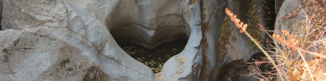
How is it possible? How is it possible that a perfectly heart-shaped hole could form in the rock wall flanking Seeley Creek Falls? This amazing formation does exist and can be reached via a short, relatively easy one-mile round trip hike in the San Bernardino Mountains near the town of Crestline. The dirt trail to Heart Rock descends 200 feet, following Seeley Creek on a gradual... Read more.
By: Published: Last updated: January 9, 2018
Marshall Peak Trail San Bernardino Mountains summit California
The San Bernardino Mountains are a rugged east-west running mountain range in San Bernardino County east of the San Gabriel Mountains. While the range tops out at the 11,500-foot summit of San Gorgonio Mountain, you can find great panoramic view from a 4,000-foot peak that is much easier to reach. Marshall Peak rises above the foothills of the mighty San Bernardino Mountains and is just a... Read more.
By: Published: Last updated: May 19, 2024
Jesusita Trail to Inspiration Point hike Santa Barbara California
Located in the Santa Ynez Mountains, 1,800-feet above Santa Barbara, Inspiration Point provides panoramic views over The American Riviera. It is a moderate 7.55 to 7.95-mile round trip trek from San Roque Road up Jesusita Trail to Inspiration Point, gradually checking off 1,400 feet of elevation gain. Those who prefer a shorter alternative, can hike from Tunnel Road and take a 3.75-mile... Read more.
OK! Add to trails I’ve hiked
OK! Add to trails I want to hike
Tagged with · Creeks · Free Trails · Ocean Views · Santa Ynez Mountains
Distance: 7.55 miles · Elevation change: 1800 feet
By: Published: Last updated: January 9, 2018
Rocky Peak Park summit hike Simi Valley Los Angeles California
Rocky Peak is a panoramic 2,715-foot summit on the border between Los Angeles and Ventura counties in the Santa Susana Mountains. The county line-straddling peak stands at the center of a 4,800-acre park bearing the same name. The shortest hike to Rocky Peak takes Rocky Peak Trail from Rocky Peak Road through Rocky Peak Park. Oh boy, we're off to a rocky start... The first two miles of... Read more.
By: Published: Last updated: December 7, 2018
Amir's Garden trail Griffith Park hike Los Angeles
Amir's Garden is no mere garden; it's one of two unique and awesome picnic areas on the east side of Griffith Park. The most surprising place for a picnic is probably the Old Zoo Picnic Area, where you can dine alongside old animal pens. Amir's Garden is the most pleasant place for a hike-in picnic, with a selection of picnic tables surrounded by a volunteer-supported sanctuary of flowering... Read more.
OK! Add to trails I’ve hiked
OK! Add to trails I want to hike
Tagged with · Free Trails · Picnic Area · Dog-Friendly Trails · Griffith Park · Santa Monica Mountains
Distance: 1 mile · Elevation change: 275 feet
By: Published: Last updated: December 7, 2018
Mount Hollywood, Mount Bell, and Mount Chapel hike peaks trails Griffith Park summit trek Griffith observatory hike
If you're interested in getting some exercise with panoramic views over Griffith Park, consider hiking a loop to the summit's of three park peaks: Mount Chapel, Mount Bell, and Mount Hollywood. Starting from Hollyridge Trail at the top of Beachwood Drive, this 5.7-mile loop ascends 675 vertical feet, from 950 feet at the trailhead to 1,625 feet at the summit of Mount Hollywood, the... Read more.
OK! Add to trails I’ve hiked
OK! Add to trails I want to hike
Tagged with · Free Trails · Hollywood · Summits · Dog-Friendly Trails · Griffith Park · Santa Monica Mountains
Distance: 5.7 miles · Elevation change: 675 feet
By: Published: Last updated: August 29, 2019
Hollyridge Trail Beachwood Canyon Hollywood Sign Hike Mount Lee Griffith Park
Hikers have several ways to reach the Hollywood Sign atop Mount Lee in Griffith Park. For a short steep hike, you could cross Cahuenga Peak for a tough 3-miler. For a lengthier 6.4-mile trek, you could hike from Brush Canyon Trail to Mount Lee. Hollyridge offers something in the middle, a 3.5-mile round trip hike that climbs 750 feet to the Hollywood Sign. Accessing the trailhead is a... Read more.
OK! Add to trails I’ve hiked
OK! Add to trails I want to hike
Tagged with · Free Trails · Hollywood · Summits · Dog-Friendly Trails · Griffith Park · Santa Monica Mountains
Distance: 3.5 miles · Elevation change: 750 feet
By: Published: Last updated: December 7, 2018
Rock Lake Trail Adirondacks Blue Mountain Lake New York hike
Several Adirondack lakes line the roadways in Hamilton County, New York (Blue Mountain Lake, Indian Lake, Long Lake, and Raquette Lake to name a few), but sometimes it is more refreshing to hike to a scenic lake that can't be seen from the road. Leave the vehicle noise behind on this easy 1.6-mile round trip hike with just 100 feet of elevation change. The pleasant trail follows a creek to... Read more.
OK! Add to trails I’ve hiked
OK! Add to trails I want to hike
Tagged with · Adirondack Mountains · Adirondack Park · Backpacking · Free Trails · Lakes
Distance: 1.6 miles · Elevation change: 100 feet
By: Published: Last updated: April 23, 2017
Sawyer Mountain Trail Adirondack Mountains New York hike
For summit views without the usual summit effort, head to Sawyer Mountain in the Adirondacks. The trail to the top of the mountain gains 650 feet over a 2.5-mile round trip hike. While the trail travels through a sheltered hardwood forest the entire way, there are two overlooks around the summit that provide far-reaching views over the trees across the surrounding valleys, ridges, and... Read more.
OK! Add to trails I’ve hiked
OK! Add to trails I want to hike
Tagged with · Adirondack Mountains · Adirondack Park · Free Trails · Summits
Distance: 2.5 miles · Elevation change: 650 feet
By: Published: Last updated: April 23, 2017
Grassy Pond Trail Adirondacks Blue Mountain Lake New York hike
The Adirondack Mountains are dotted with lakes and mountains, so it should come as no surprise that you can hike to one or two peaceful ponds on this trail near Eagle Lake and Blue Mountain Lake. For those looking for something on the shorter side, it is an easy one-mile round trip hike to Grassy Pond. For those looking to immerse themselves in the Adirondacks, hike past Grassy Pond for a... Read more.
OK! Add to trails I’ve hiked
OK! Add to trails I want to hike
Tagged with · Adirondack Mountains · Adirondack Park · Blue Mountain Lake · Free Trails · Lakes
Distance: 1 mile · Elevation change: 75 feet
By: Published: Last updated: April 23, 2017