Hazard Peak Loop Hazard Peak Trail East Boundary Barranca Trail Islay Creek Trail Montaña de Oro State Park hike
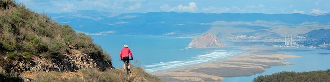
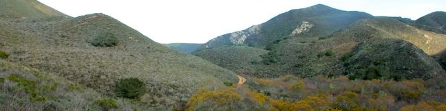
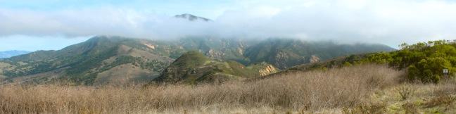
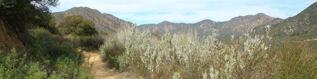
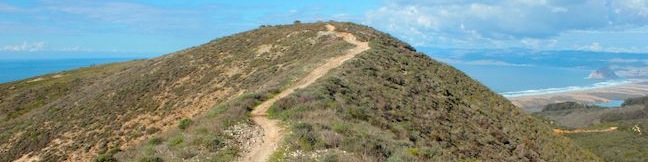
The hike up and down Hazard Peak Trail delivers a heavy dose of ocean views. While it could be argued that this 6-mile round trip hike is the finest trek to the summit of Hazard Peak, you may wish to consider elongating that hike to a 9.2-mile loop that returns to the coast via Islay Creek Trail in the adjacent Islay Creek Canyon. Sacrificing a second helping of ocean views, the loop... Read more.
OK! Add to trails I’ve hiked
OK! Add to trails I want to hike
Tagged with · California State Parks · Free Trails · Irish Hills · Los Osos · Ocean Views · Summits · Montaña de Oro State Park
Distance: 9.2 miles · Elevation change: 1000 feet
By: Published: Last updated: September 10, 2018
Hazard Peak Trail Montaña de Oro State Park summit hike
Montaña de Oro State Park is packed with so many picturesque places that it can be difficult to settle on just one day hike. However, if you are looking for broad, unobstructed view over Morro Bay, you should feel compelled to set out for the top of Hazard Peak. Looking north from this coastal 1,076-foot summit, you won't see anything even half as tall as Hazard Peak for about 15 miles,... Read more.
By: Published: Last updated: May 20, 2017
Islay Creek Trail Montaña de Oro State Park hike
Montaña de Oro State Park has a couple lengthy level hikes. If you desire ocean views, you can't do any better than the Bluff Trail. If you would rather hike up a canyon flanked by thousand foot peaks along a creek that even has a small waterfall, the fitting trail is Islay Creek Trail. The rolling 3-mile long dirt road has 300-feet of easy elevation change. Just before the trail ends at... Read more.
By: Published: Last updated: May 11, 2017
Valencia Peak Trail Montaña de Oro State Park hike
At 1,347 feet, Valencia Peak is one of the highest summit in Montaña de Oro State Park and may provide the best panorama of the park's stunning shoreline and inviting inland peaks. The views are epic and the hike is 4.5-miles round trip with 1,275 feet of elevation. An older version of Valencia Peak Trail was 0.4 miles shorter each way, and the new route uses more switchbacks to ease the... Read more.
OK! Add to trails I’ve hiked
OK! Add to trails I want to hike
Tagged with · California State Parks · Free Trails · Irish Hills · Los Osos · Ocean Views · Summits · Montaña de Oro State Park
Distance: 4.5 miles · Elevation change: 1275 feet
By: Published: Last updated: January 24, 2018
Morro Strand Trail Morro Strand State Beach Morro Rock Cloisters Park Cloisters Wetlands San Luis Obispo Morro Bay California beach hike stroll walk sand lagoon central coast
Morro Rock is an iconic landmark on California's Central Coast. Located north of San Luis Obispo, the 578-foot tall mass of volcanic rock rises above of the Pacific Ocean, separating the inviting sands of Morro Strand State Beach from the blue waters of Morro Bay Harbor. Starting from a protected coastal wetland along Highway One in Morro Bay, this easy beach hike crosses sand dunes into... Read more.
OK! Add to trails I’ve hiked
OK! Add to trails I want to hike
Tagged with · Free Trails · Morro Bay · Morros · Ocean Views
Distance: 3.5 miles · Elevation change: 25 feet
By: Published: Last updated: January 16, 2018
Carpinteria Bluffs Trail to Carpinteria Seal Sanctuary Overlook in Carpinteria Bluffs Nature Preserve
You could call a hike easy if it was less a mile long and almost completely level. You could call a hike easy to reach if the trailhead was right at the end of a freeway offramp. You could call a hike easy to enjoy if it offered lovely coastal views and almost guaranteed wildlife viewing. Introducing the easy-to-reach, easy-to-enjoy, and all around easy hike from Carpinteria Bluffs Nature... Read more.
By: Published: Last updated: February 12, 2018
Gaviota Pass Overlook hike Gaviota State Park Trails Lompoc California
Gaviota State Park preserves 2,787 oceanfront acres in the rugged and beautiful Santa Ynez Mountains west of Santa Barbara. If the park was not sliced down the middle by Highway 101, it would surely be one of the most popular state parks on the Central Coast. The presence of the freeway certainly cuts down on crowds, enabling hikers to enjoy the largely untainted scenery in relative... Read more.
By: Published: Last updated: April 24, 2017
Fisherman's Camp Trail San Mateo Canyon Wilderness Santa Ana Mountains trail campground hike Tenaja Canyon
Once you break out of the trees at the trailhead, broad canyon views stay with you the way to Fisherman's Camp in the San Mateo Canyon Wilderness. Fisherman's Camp Trail descends 1.66 miles down what was once a road to what was once a campground nestled at the mouth of Tenaja Canyon. Grassy plots remain where backpackers can put up a tent in the shady creek-side retreat. Campfires are... Read more.
By: Published: Last updated: September 10, 2018
Carbon Canyon Regional Park Redwood Grove Nature Trail to the Redwoods
Everyone knows that Northern California is the place to go to see groves of giant redwoods, but few people know that you can get a taste of the redwoods in Southern California. Carbon Canyon Regional Park in Brea has a 10-acre grove of coastal redwoods, the largest grove of these trees in Southern California. Even through the could-be giants are relatively young and not really suited for the... Read more.
OK! Add to trails I’ve hiked
OK! Add to trails I want to hike
Tagged with · Brea · Carbon Canyon Regional Park · Nature Trails · Orange County Parks · Redwood Groves
Distance: 2.5 miles · Elevation change: 75 feet
By: Published: Last updated: April 19, 2017
Ortega Falls Santa Ana Mountains Ortega Highway waterfall hike trail
How far would you be willing to hike to reach an idyllic swimming hole beneath a 35-foot waterfall - 5 miles, 10 miles? In fact, you will only have to hike a third of a mile round trip to reach Ortega Falls, a refreshing seasonal waterfall just off Ortega Highway in the Santa Ana Mountains. The hike begins from an unmarked turnout on Ortega Highway in a beautiful part of the Santa Ana... Read more.
By: Published: Last updated: January 15, 2018