Getty View Park hike East Sepulveda Fire Road Trail Casiano Fire Road trek Santa Monica Mountains Getty Museum vista
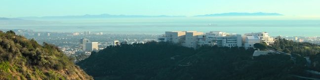
The Getty Museum sits on a ridge in the Santa Monica Mountains above the 405 Freeway and has sweeping views over the west side of Los Angeles. East Sepulveda Fire Road (also known as Casiano Fire Road) crosses the ridge on the opposite side of the freeway and has great views of the Getty Museum and Santa Monica Bay. The wide dirt trail crosses a protected section of the Santa Monica... Read more.
By: Published: Last updated: April 16, 2017
Moonstone Beach Boardwalk in Cambria San Luis Obispo County California Big Sur Coast beach hike stroll walk central coast
The city of Cambria is located on Highway One at the north end of San Luis Obispo County, and has earned the nickname "Gateway to the Big Sur Coast." Like that stunning area to the north, Cambria has its own beautiful waterfront. Explore sandy beaches and rocky tide pools on a 2.85-mile round trip hike down Moonstone Beach Boardwalk, crossing a pristine beach that is preserved by Hearst San... Read more.
By: Published: Last updated: April 16, 2017
Pacific Valley Bluff Trail Big Sur hike Los Padres National Forest Ocean view bluff hike
This short, level hike in Big Sur's Los Padres National Forest ventures to the end of a grassy point topped by a crown of spiked boulders. The bluff offers fantastic views of the coves and rocky sea stacks up and down the rugged coastline of Big Sur. The trailhead is conveniently located along Highway One, and at 1.1 miles round trip with 50 feet of elevation change, the views far outweigh... Read more.
OK! Add to trails I’ve hiked
OK! Add to trails I want to hike
Tagged with · Big Sur · Free Trails · Los Padres National Forest · Ocean Views
Distance: 1.1 miles · Elevation change: 50 feet
By: Published: Last updated: April 16, 2017
Crystal Cove State Park Moro Beach Trail El Moro Visitor Center hike Laguna Beach
Crystal Cove State Park has two main draws, the beach and the backcountry, so why not get a bit of both? The El Moro Visitor Center is the main trailhead for hikes into the backcountry (like Geology Discovery Trail), and it can also be the starting point of a 2-mile round trip hike to Moro Beach. This distance can easily be extended by exploring more of Moro Canyon and the surrounding... Read more.
By: Published: Last updated: April 16, 2017
Crystal Cove State Park hike Geology Discovery Trail Backcountry Loop Moro Canyon Road Rattlesnake Trail No Name Ridge Trail El Moro back country trail
Crystal Cove State Park is one of Orange County's finest places to enjoy the outdoors. The park preserves 3.2 miles of coastline between Laguna Beach and Corona del Mar and 2,400 acres of backcountry wilderness (bordering Laguna Coast Wilderness Park). An excellent way to explore the coastal canyons and ridges in the backcountry of Crystal Cove State Park is to set out on Geology Discovery... Read more.
By: Published: Last updated: January 9, 2018
Lake Huntington loop hike in Huntington Beach Central Park Huntington Lake Trail
To describe this hike, you have to use a couple phrases that you wouldn't normally associate with Orange County, Central Park and Lake Trail, but you will also use a few phrases that are quite fitting for Southern California, laid back and leisurely. Like the Big Apple, there is a Central Park in Huntington Beach (the Big Orange?) with over 350 acres of green space just a couple miles from... Read more.
OK! Add to trails I’ve hiked
OK! Add to trails I want to hike
Tagged with · Central Park · Free Trails · Huntington Beach · Lakes
Distance: 0.75 miles · Elevation change: 25 feet
By: Published: Last updated: April 16, 2017
Crown Prince Lookout Trail in Joshua Tree National Park Crown Prince Overlook hike World War Two Lookout Point Joshua Tree hike
Joshua Tree National Park has a lot of interesting history, like old gold mines and Native America sites. Crown Prince Lookout highlights another period of the park's history, when a warning station for World War II airplanes was located atop a granite formation near today's overlook. The lookout and a second nearby viewpoint can be reached via an easy 3.25-mile round trip hike up an old... Read more.
OK! Add to trails I’ve hiked
OK! Add to trails I want to hike
Tagged with · National Parks · Off Trail
Distance: 3.25 miles · Elevation change: 50 feet
By: Published: Last updated: January 16, 2020
Ryan Ranch in Joshua Tree National Park Ryan Mountain Ruins hike Ryan Campground trail to Ryan Ranch Joshua Tree National Park California
Despite the harshness of the desert environment, some people actually made a home in what is now Joshua Tree National Park. Miners, Jepp and Tom Ryan built a large house next to Ryan Mountain in 1898. Over a hundred years later, much of their old adobe structure still stands and can be easily visited today. Two routes lead to the ruins of Ryan Ranch. If you are staying at Ryan... Read more.
OK! Add to trails I’ve hiked
OK! Add to trails I want to hike
Tagged with · National Parks · Ruins
Distance: 1.2 miles · Elevation change: 85 feet
By: Published: Last updated: January 16, 2020
Bajada Trail in Joshua Tree National Park Bajada All-Access Nature Trail hike California desert botany trail
Bajada All-Access Nature Trail is located on the southeast side of Joshua Tree National Park between the 10 Freeway and the Cottonwood Visitor Center. The hike, which you could do in flip-flops or tennis shoes, is a 0.3-mile loop with about 5 feet of elevation change. If that wears you out, there are three benches along the way where you can pause to admire the vegetation and scenery. ... Read more.
OK! Add to trails I’ve hiked
OK! Add to trails I want to hike
Tagged with · National Parks · Nature Trails
Distance: 0.3 miles · Elevation change: 5 feet
By: Published: Last updated: April 17, 2017
Vanalden Cave Hike hike Vanalden Trail vista point Santa Monica Mountains Vanalden Vista
Vanalden Cave near Tarzana is one of the most unusual sandstone formations in the Santa Monica Mountains and is quite easy to hike to. Vanalden Cave is a sandstone den about 25 feet tall, 25 feet wide, and 50 feet deep. The roof of the cave is only a few feet thick with a few holes that, like skylights, illuminate cave walls covered with curious carvings and graffiti. Hike 0.6 miles... Read more.
OK! Add to trails I’ve hiked
OK! Add to trails I want to hike
Tagged with · Bike Trail · Caves · Free Trails · Tarzana · Dog-Friendly Trails · Santa Monica Mountains
Distance: 0.6 miles · Elevation change: 100 feet
By: Published: Last updated: January 17, 2018