Watkin Powell Track New Zealand Tauwhara Bay Otamure Bay walking track hike Northland
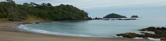
Watkin Powell Track offers a short walk to a secluded beach near Otamure Bay Campground in Northland, New Zealand, and it is 1/3 of a kilometer round trip. This is an over-the-top hike that you'll walk up, over, and down a small ridge to reach the beach at Tauwhara Bay. Once there, you can snorkel and swim to your heart's content, or continue walking along a crescent-shaped cove that faces... Read more.
OK! Add to trails I’ve hiked
OK! Add to trails I want to hike
Tagged with · Beaches · New Zealand Department of Conservation · Ocean Views · Tauwhara Bay · Whananaki North
Distance: 0.33 kilometers / 0.2 miles · Elevation change: 20 meters / 65 feet
By: Published: Last updated: December 28, 2020
Piedras Blancas Elephant Seal Rookery trail to Piedras Blancas Light Station hike Point Piedras Blancas Lighthouse San Simeon California Northern Elephant Seal Colony Big Sur
Very few places in nature would you feel comfortable getting up close to 5,000-pound animals. Piedras Blancas Elephant Seal Rookery is one of them. While visiting the seal colony, you can get up close to these impressive (and vocal) animals and observe them in their natural habitat. In addition to two quarter-mile long boardwalk trails, the rookery is also the starting point for a dirt... Read more.
By: Published: Last updated: September 10, 2019
Vasquez Rocks Natural Area Park hike Agua Dulce Los Angeles County Park Pacific Crest Trail Foot Trail Loop Famous Rocks trek
Vasquez Rocks Natural Area Park is a dramatic desert wonderland, with striking rock formations that point skyward at a 45-degree angle. This 932-acre Los Angeles County Park delivers a scenic desert backdrop for hikers, and is just a quick drive from LA. This pairing of unique beauty and convenience has made Vasquez Rocks a popular location for the film industry and the park has a long list... Read more.
By: Published: Last updated: August 29, 2019
Rock Spring Mojave National Park Rock Spring Loop Trail Rock House Hike
Water is something you don't see much of in Mojave National Preserve, certainly not just pooling on the ground as it does at Rock Spring. The constant source at Rock Spring helped inhabitants survive in the Mojave Desert for thousands of years and was even the site of a small U.S. Army post in the 1860s. Today you can reach the spring easily, along with a Rock House built in the 1920s and... Read more.
OK! Add to trails I’ve hiked
OK! Add to trails I want to hike
Tagged with · Desert Canyons · Free Trails
Distance: 1.33 miles · Elevation change: 100 feet
By: Published: Last updated: January 11, 2018
Clark Reservation State Park New York Syracuse hike Cliff Trail Long Trail Mildred Faust Trail
The New York State Park website describes Clark Reservation as 'a geologic wonder of the last ice age and a botanist's paradise.' It's all that and just 5 miles from Syracuse! The star of the park is Glacier Lake, a glacial plunge pool lake surrounded by dramatic limestone cliffs. Over a dozen trails explore this 365-acre park, allowing visitors to put together several different hikes. ... Read more.
OK! Add to trails I’ve hiked
OK! Add to trails I want to hike
Tagged with · Clark Reservation State Park · Jamesville · Lakes · New York State Parks · Onondaga County
Distance: 1.95 miles · Elevation change: 150 feet
By: Published: Last updated: January 11, 2018
North County National Scenic Trail hike Hang Glider Launch Site Labrador Hollow Unique Area New York State Forest
For a soaring view over Labrador Hollow Unique Area, a state forest in Central New York, take a hike up Jones Hill to a scenic overlook at a Hang Glider Launch Site. There are two overlapping routes to the launch site from the trailhead for Tinker Falls Trail (a short hike to a lovely waterfall). Onondaga Sky Line Trail is a wide dirt road offering a 1.2-mile route to the overlook marked... Read more.
OK! Add to trails I’ve hiked
OK! Add to trails I want to hike
Tagged with · Cortland County · Labrador Hollow Unique Area · New York State Forests · Onondaga County · Tully
Distance: 2.5 miles · Elevation change: 650 feet
By: Published: Last updated: April 12, 2017
Tinker Falls Trail Labrador Hollow Unique Area Waterfall hike Tully New York State Forest
Tinker Falls is a beautiful 50-foot waterfall in Labrador Hollow Unique Area, a New York State Department of Environmental Conservation (NYSDEC) State Forest on the border of Onondaga County and Cortland County in Central New York. The base of the waterfall can be reached via Tinker Falls Trail on an easy half-mile round trip hike with 50 feet of elevation gain. It is also possible to hike... Read more.
By: Published: Last updated: April 12, 2017
Labrador Hollow Boardwalk New York State Forest hike Labrador Hollow Unique Area
Tranquil Labrador Pond lies at the heart of New York State's Labrador Hollow Unique Area on the border of Onondaga County and Cortland County. Fine views of Labrador Pond can be found on Labrador Hollow Boardwalk, a half-mile long wheelchair-friendly walkway through the wetlands bordering Labrador Pond. The quick walk reaches a viewpoint on the shore of the hill-cradled pond and is a great... Read more.
By: Published: Last updated: April 12, 2017
Beaver Lake Nature Center Winter Trails Snowshoeing Onondaga County Park Baldwinsville New York Southern Exposure Snowshoe Trail
When the snow falls in Central New York, it's time to trade in your hiking books for snowshoes and explore a wonderland of winter landscapes. Onondaga County's Beaver Lake Nature Center is a perfect destination for winter fun. The 660-acre park operates trails for snowshoeing and cross-country skiing, and even rents snowshoes for a small fee so that everyone can get in on the fun. There are... Read more.
By: Published: Last updated: April 23, 2017
Canyon View Loop Trail Whitewater Preserve Pacific Crest Trail San Bernardino Mountains Palm Springs hike
You would not expect to find a Whitewater River in the vicinity of Palm Springs, but this surprising river is vital for the fertility of the Coachella Valley, bringing wonderful water from the San Bernardino Mountains to the desert below where it empties into the Salton Sea. Journeyman hikers can pass through Whitewater Preserve on the Pacific Crest Trail and day hikers can get in on the... Read more.
OK! Add to trails I’ve hiked
OK! Add to trails I want to hike
Tagged with · Creeks · Free Trails · Pacific Crest Trail · San Bernardino Mountains · Whitewater Preserve
Distance: 3.75 miles · Elevation change: 650 feet
By: Published: Last updated: January 10, 2018