Mangawhero Falls Walking Track Tongariro National Park Hike Ohakune New Zealand
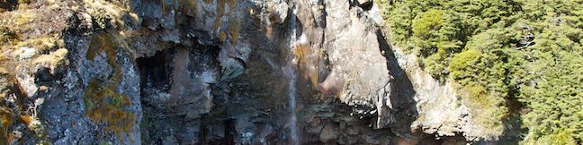
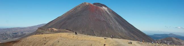
Tongariro National Park has many wonders. Some are impossible to miss, like massive volcanoes, and other, like beautiful waterfalls, are waiting to be discovered. Mangawhero Falls plunges 25 meters (80 feet) in a beautiful setting. The waterfall is below Mount Ruapehu, New Zealand's largest volcano and the highest peak on the North Island. Reach the waterfall on an easy 300-meter round... Read more.
OK! Add to trails I’ve hiked
OK! Add to trails I want to hike
Tagged with · Free Trails · New Zealand Department of Conservation · New Zealand National Parks · Ohakune · Waterfalls · Tongairo National Park
Distance: 0.3 kilometers / 0.2 miles · Elevation change: 10 meters / 30 feet
By: Published: Last updated: May 6, 2017
Tongariro Alpine Crossing Hike Tongariro National Park Volcanoes Day Walk New Zealand
Tongariro Alpine Crossing is widely consider one of the greatest day hikes in New Zealand, which puts it on the shortlist of the world's greatest hikes. This 19.4-kilometer long track rises to its reputation and then some, crossing through an active volcanic area in Tongariro National Park at the center of New Zealand's North Island. It is one of the most dynamic and dramatic hikes that you... Read more.
OK! Add to trails I’ve hiked
OK! Add to trails I want to hike
Tagged with · Craters · Free Trails · Huts · New Zealand National Parks · Volcanoes · Tongairo National Park
Distance: 19.4 kilometers / 12 miles · Elevation change: 1125 meters / 3690 feet
By: Published: Last updated: August 27, 2019
Cherry Canyon Park hike Ultimate Destination Vista Point Lookout Tower Cherry Canyon Motorway Ridge Motorway Descanso Trail Cherry Canyon Trail Ultimate Destination Trail
Cherry Canyon Park preserves over 130 acres in the San Rafael Hills, a small mountain range east of the Verdugo Mountains and south of the San Gabriel Mountains in the city of La Cañada Flintridge. The park has many trails, including wide fire roads suitable for horses and mountain bikes and single tracks strictly for hikers. For a good overview of the area, consider hiking to an old... Read more.
OK! Add to trails I’ve hiked
OK! Add to trails I want to hike
Tagged with · Free Trails · La Cañada Flintridge · Lookout Towers · San Rafael Hills · Dog-Friendly Trails
Distance: 2.5 miles · Elevation change: 500 feet
By: Published: Last updated: December 7, 2018
High View Nature Trail Joshua Tree National Park Hike Black Rock Canyon Hi-View Trail
While many national park nature trails are short, level, and informative, High View Nature Trail offers a bit more for hikers, 325 feet of elevation gain on a 1 1/3-mile loop. The trail ascends a desert ridge with views over Yucca Valley and toward Southern California's tallest peak, San Gorgonio Mountain, in the mountains to the west. The loop starts near Black Rock Campground on the west... Read more.
OK! Add to trails I’ve hiked
OK! Add to trails I want to hike
Tagged with · National Parks · Nature Trails · Yucca Valley
Distance: 1.35 miles · Elevation change: 325 feet
By: Published: Last updated: January 9, 2018
Coon Creek Trail Montaña de Oro State Park hike Coon Creek Canyon Montana de Oro San Luis Obispo California
Coon Creek Trail explores a coastal canyon at the south end of Montaña de Oro State Park. The trail heads inland for 2.5 miles to a pleasant grove of Monterey cypress at the site of an old homestead that has since disappeared. Take a break in the shade of the cypress trees before turning around for a 5-mile round trip hike with 250 feet of elevation gain. Junctions with Rattesnake Flats... Read more.
OK! Add to trails I’ve hiked
OK! Add to trails I want to hike
Tagged with · California State Parks · Creeks · Free Trails · Los Osos · Montaña de Oro State Park
Distance: 5 miles · Elevation change: 250 feet
By: Published: Last updated: May 11, 2017
Coal Mines Historic Site Convict Precinct Walk Tasman Peninsula Tasmania Australia Hike Penal Colony Tour
If you think being a prisoner at a Tasmanian penal colony sounds bad, add coal mining to that prison sentence and you get something truly awful. Such was the case in the 1830s and 40s when, just after the famous Port Arthur Penal Colony was established, convict laborers were sent to another part of the Tasman Peninsula to work in coal mines (and you can imagine that working conditions in the... Read more.
OK! Add to trails I’ve hiked
OK! Add to trails I want to hike
Tagged with · Mines · Ocean Views · Ruins · Saltwater River · Tasman Peninsula
Distance: 0.8 kilometers / 0.5 miles · Elevation change: 10 meters / 30 feet
By: Published: Last updated: May 6, 2017
Cape Raoul Track Tasman Peninsula Bushwalk Tasman National Park Stormlea Tasmania Cape Raoul Cliffs Walk
With some of the tallest sea cliffs in Australia, Cape Raoul is a daunting promontory jutting south from the Tasman Peninsula. While it is listed as one of Tasmania's 60 Great Short Walks, this hike is longer and harder than other tracks on that list at 12 to 14 kilometers (7.45 to 8.7 miles) round trip. The out and back bushwalk follows a track through wild vegetation in Tasman National... Read more.
OK! Add to trails I’ve hiked
OK! Add to trails I want to hike
Tagged with · Ocean Views · Tasman National Park · Tasman Peninsula · Tasmania's 60 Great Short Walks
Distance: 14 kilometers / 8.7 miles · Elevation change: 240 meters / 790 feet
By: Published: Last updated: May 19, 2024
Tasmans Arch Devils Kitchen Lookout Tasman Peninsula Walk Tasman National Park Eaglehawk Neck Devil's Kitchen Tasman's Arch Sea Cliffs
The Tasman Peninsula extends into the Tasman Sea in the southeast corner of Tasmania. While the peninsula was once used as a penitentiary, a visit to the peninsula's impressive coastline today will feel like anything but prison. Just south of the narrow isthmus at Eaglehawk Neck, the east coast of the peninsula has several easy-to-reach wonders, including Tasmans Arch and Devils Kitchen (as... Read more.
OK! Add to trails I’ve hiked
OK! Add to trails I want to hike
Tagged with · Australian National Parks · Eaglehawk Neck · Natural Bridges · Ocean Views · Tasman National Park · Tasman Peninsula
Distance: 0.9 kilometers / 0.55 miles · Elevation change: 5 meters / 15 feet
By: Published: Last updated: May 19, 2024
Tasman Blowhole Fossil Bay Lookout Tasman Peninsula Tasman National Park The Blowhole Eaglehawk Neck Doo Town Fossil Bay Walk
The Tasman Peninsula extends into the Tasman Sea in the southeast corner of Tasmania. While the peninsula was once used as a penitentiary, a visit to the peninsula's impressive coastline today will feel like anything but prison. Just south of the narrow isthmus at Eaglehawk Neck, the east coast of the peninsula has several easy-to-reach wonders, including the Blowhole and Fossil Bay Lookout... Read more.
OK! Add to trails I’ve hiked
OK! Add to trails I want to hike
Tagged with · Australian National Parks · Blowholes · Eaglehawk Neck · Ocean Views · Tasman National Park · Tasman Peninsula
Distance: 0.45 kilometers / 0.3 miles · Elevation change: 10 meters / 30 feet
By: Published: Last updated: May 19, 2024
Hazards Beach Wineglass Bay Circuit Freycinet National Park Wineglass Bay Track Loop Tasmania Australia Freycinet Peninsula Hazards Beach Track Wineglass Bay Lookout Hike
Wineglass Bay is one of the top-rate beaches in Australia, and a premier destination for hikers in Freycinet National Park. A great way to see Wineglass Bay and the beautiful beach on the opposite side of the peninsula is to hike Wineglass Bay and Hazards Beach Circuit. This loop loop is 11.5 kilometers (7.15 miles) long, or a bit farther if you walk out along the beach at Wineglass Bay and... Read more.
OK! Add to trails I’ve hiked
OK! Add to trails I want to hike
Tagged with · Australian National Parks · Beaches · Coles Bay · Freycinet National Park · Freycinet Peninsula · Ocean Views
Distance: 12 kilometers / 7.45 miles · Elevation change: 213 meters / 700 feet
By: Published: Last updated: May 19, 2024