Oso Flaco Lake Trail Oceano Dunes SCRA Nipomo Dunes Hike San Luis Obispo California
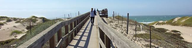
Oso Flaco Lake Trail in Oceano Dunes SVRA offers a hike with easy-going appeal. The nearly level trail takes a boardwalk over a 75-acre birdlife-boasting lake and across sand dunes to a tucked-away beach and a viewpoint overlooking the Guadalupe-Nipomo Dunes. These are the largest dunes on the coast of Southern California, but Oso Flaco Lake Trail is a short hike at just 2-miles round trip.... Read more.
By: Published: Last updated: January 24, 2018
Arroyo Sequit Park Santa Monica Mountains National Recreation Area Arroyo Sequit Nature Trail
Take a trip to Arroyo Sequit Park to hike a short loop through a tucked-away pocket of the Santa Monica Mountains, The park is situated along Mulholland Highway inland of Leo Carrillo State Park and below the range's most rugged peaks. The surroundings for this 2.05 miles hike are beautiful. Arroyo Sequit Nature Trail has 285 feet of elevation change, winding over and around the upper... Read more.
By: Published: Last updated: December 7, 2018
Nicholas Flat Trail Willow Creek Trail Ocean Vista Hike Malibu Leo Carrillo State Park Scenic Loop hike Santa Monica Mountains
At the west end of Malibu where Mulholland Highway meets PCH, you'll find Leo Carrillo State Park. Well known for its beaches and surfing, this park has offerings for hikers too, like the trek up Nicholas Flat Trail to an oak-wrapped grassland with a small pond, which is 7 miles round trip or more. For a shorter hike, combine the bottom of Nicholas Flat Trail with Willow Creek Trail, for a... Read more.
OK! Add to trails I’ve hiked
OK! Add to trails I want to hike
Tagged with · California State Parks · Leo Carrillo State Park · Malibu · Ocean Views · Santa Monica Mountains
Distance: 2.05 miles · Elevation change: 620 feet
By: Published: Last updated: October 8, 2024
Nicholas Flat Trail Hike Malibu Leo Carrillo State Park Nicholas Flat Natural Preserve Santa Monica Mountains California
Nicholas Flat Trail is a three-mile long 'ocean to mountains' trail beginning within Leo Carrillo State Park, just across PCH from a famous beach at the west end of Malibu. The single-track trail travels up a coastal ridge past two vista points (and lots of other ocean views) to reach Nicholas Flat, where grassy meadows are rimmed by oak trees. A small network of trails offer different... Read more.
By: Published: Last updated: October 8, 2024
Guler Ice Cave hike Washington Gifford Pinchot National Forest
The Cascade Range is home to many caves including volcanic lava tubes and glacier ice caves. The Guler Ice Cave south of Mount Adams offers a sample of both. Through the early summer this cave contains impressive ice features like frozen stalactites and stalagmites. You will see the most ice if you visit in April and May. As the season warms the cave loses its ice, but remains fun to... Read more.
OK! Add to trails I’ve hiked
OK! Add to trails I want to hike
Tagged with · Cascade Range · Caves · Gifford Pinchot National Forest · Lava Tubes
Distance: 0.25 miles · Elevation change: 25 feet
By: Published: Last updated: October 8, 2024
Bailey Cove Trail Shasta Lake Hike Shasta-Trinity National Forest California
Bailey Cove Trail follows an easy path that weaves along the edges of a roughly triangle-shaped peninsula extends into Shasta Lake. A hill rises over the center of the peninsula, which is framed by finger-like coves on two sides. Lake views are present throughout this 3.1-mile hike and are grandest during the second mile. Bailey Cove Trail is fairly level, with just 50 feet of elevation... Read more.
OK! Add to trails I’ve hiked
OK! Add to trails I want to hike
Tagged with · Lakes · Shasta-Trinity National Forest
Distance: 3.1 miles · Elevation change: 50 feet
By: Published: Last updated: April 23, 2017
Chumash Trail Crespi Trail Hutash Trail Loop Morro Bay State Park San Luis Obispo hike California Turri Road
While it is one of the more inland hikes in Morro Bay State Park, the loop formed by connecting Chumash Trail, Crespi Trail, and Hutash Trail delivers ample coastal views as it leads to a lovely grove of coast live oaks. This lollipop loop covers 2.9 miles with 420 feet of elevation change. Hutash Trail can be trimmed from the circuit to lower the round trip distance to 2.55 miles and... Read more.
OK! Add to trails I’ve hiked
OK! Add to trails I want to hike
Tagged with · California State Parks · Free Trails · Morro Bay · Morro Bay State Park · Ocean Views
Distance: 2.9 miles · Elevation change: 420 feet
By: Published: Last updated: January 11, 2018
Terrace Hill Open Space hike San Luis Obispo California Terrace Hill Loop
An interesting chain of conical volcanoes, or volcanic plugs called the Morros, graces San Luis Obispo County. Terrace Hill is one of the smaller and harder to identify Morros within the city of San Luis Obispo County. Unlike the other Morros, Terrace Hill has a broad flat summit. The top of the hill was removed for use as construction material in the 1920s, leaving behind a flat mesa-like... Read more.
OK! Add to trails I’ve hiked
OK! Add to trails I want to hike
Tagged with · Free Trails · Morros
Distance: 0.55 miles · Elevation change: 110 feet
By: Published: Last updated: April 2, 2019
Dixie Canyon Park Hike Sherman Oaks Santa Monica Mountains
Dixie Canyon Park preserves twenty tucked-away acres in the Santa Monica Mountains on the north side of the range west of Coldwater Canyon. The park can be accessed from Sherman Oaks for a micro hike that is 0.55 miles round trip with 175 feet of elevation change. This partial loop follows a dirt single track that is narrow and sometime overgrown, finding shade from walnut trees and coast... Read more.
By: Published: Last updated: January 14, 2019
Terwilliger Hot Springs Willamette National Forest Oregon Hike Cougar Hot Springs Terwilliger Falls
Terwilliger Hot Springs (also known as Cougar Hot Springs) is a five-tiered pool accessible with 0.9 miles of easy hiking. The hot springs is located in Willamette National Forest, halfway between Eugene and Bend, Oregon. Potential visitors should know that clothing is optional at the hot springs. Those who are uncomfortable with nudity may wish to seek warm waters elsewhere. If you choose... Read more.
OK! Add to trails I’ve hiked
OK! Add to trails I want to hike
Tagged with · Cascade Range · Hot Springs · Waterfalls · Willamette National Forest
Distance: 0.9 miles · Elevation change: 85 feet
By: Published: Last updated: May 21, 2024