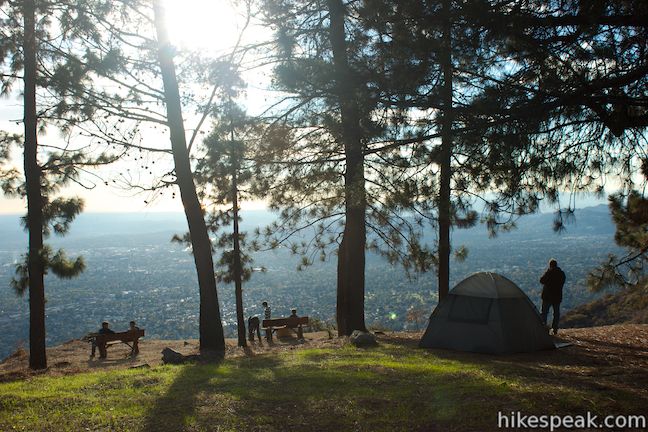
Henninger Campground is a sprawling trail camp in a scenic and special pine forest on Henninger Flats in the San Gabriel Mountains. From Altadena, it is a 3-mile one-way hike up Mount Wilson Toll Road to Henninger Flats, where the charming campground is accompanied by a visitor information center and tree nursery operated by the Los Angeles County Fire Department. The campground has around thirty first-come first-serve sites available year-round at no charge. Henninger Flats sits on a landing above steep mountain slopes, offering campers a shaded perch with panoramic views over the east end of the San Gabriel Valley.

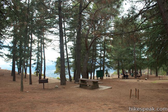
Located at 2,550 feet above sea level, you should only expect to find slightly cooler evening temperatures at Henninger Flats than in the cities below like Altadena, Pasadena, and Azusa. The charming campground, visitor center, and tree nursery attract a lot of day hikers, but campsites are usually easy to come by. Dogs are allowed on leashes in Henninger Campground. The maximum stay is 7 nights. Fire rings, grills, picnic tables, vault toilets, and drinking water are available. As an added bonus, firewood is also provided for free!
Campsites at Henninger Flats are spread out on three tiers (Lower Campground, Upper Campground, and Fuji Campground) with around ten sites on each tier. In addition to family sized sites, larger group sites have picnic tables that can seat a couple dozen people.
You will pass through the Lower Campground as you enter Henninger Flats on Mount Wilson Toll Road. To reach the Upper Campground a Fuji Campground, continue another 0.3 miles up the road to a junction with a half-mile long campground loop road. Turn right to hike a short distance to the Upper Campground. For Fuji Campground, hike less than a tenth of a mile farther up Mount Wilson Toll Road and turn right down the other end of the campground loop, which quickly reaches Fuji Campground. In addition to these wide dirt roads, more direct footpaths connect the tiers of Henninger Campground. There are 16 numbered campsites on map posted on the Los Angeles County Fire Department website, but foresters posted at Henninger Flats say that the number of sites is closer to thirty.

Free permits are required to camp at Henninger Flats and to have campfires. No permit is required to hike up Mount Wilson Toll Road to Henninger Flats (and it’s free too), so trek up to the visitor information center to get you camping and campfire permits. Check-in at the visitor information center before setting up camp and remember to bring a photo ID to obtain the permits. The Los Angeles County Fire Department website explains that:
A County of Los Angeles Fire Department Forester is on duty at Henninger Flats seven days a week including holidays. Our friendly staff will issue campfire permits, good only for Henninger Flats camp stoves.
Within the Henninger Flats Visitor Information Center you will find a relief map of the San Gabriel Mountains and information about the history of Henninger Flats, the tree nursery, and animals in the San Gabriel Mountains.
William Henninger was the first settler to build a home on the flats that bear his name in 1880. He constructed a water system for a garden that would eventually became an important nursery for reforestation efforts in California. A test forest of pines, cedars, and other conifers was developed on Henninger Flats to help early Angelinos determine which trees would grow best around Los Angeles. The Los Angeles County Fire Department website for Henninger Flats explains:
In 1892, Henninger was visited by T. P. Lukens and R. J. Busch. With Henninger’s permission, Lukens and Busch started the first experimental reforestation in California at the Flats in 1892 by planting some selected conifers.
Trees that thrived on Henninger Flats were planted all over Los Angeles County and beyond. Henninger Flats continues as a nursery even today, where trees used for conservation purposes are available to the public for free from December through March. To learn more about the nursery, ask a forester stationed in the visitor information center for a tour.
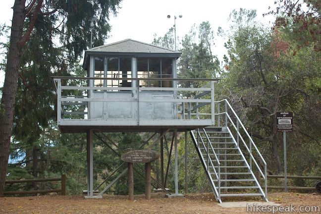
Outside the info center is a fire lookout tower that was brought to Henninger Flats from Castro Peak in the Santa Monica Mountains, where it was in service from 1915 to 1971. Take the ladder up into the tower and peer through the glass windows into the well-preserved lookout station.
Fire lookout towers are a great part of the history of the San Gabriel Mountains and other mountain ranges in the west, so it is fitting that the lookout tower is being preserved by the Los Angeles County Fire Department on Henninger Flats.

To learn more about the trek to Henninger Flats, check out this longer description of the hike up Mount Wilson Toll Road to Henninger Flats. For additional information on Henninger Campground, contact the Los Angeles County Fire Department foresters at Henninger Flats by calling 626.794.0675.
To get to the campground: Take the 210 Freeway to Pasadena to exit 29 for Altadena Drive. Head north on Altadena Drive for 2.7 miles and turn right on Crescent Drive. At the next intersection you will reach Pinecrest Drive. Turn right and find the start of Mount Wilson Toll Road on the right, a tenth of a mile up Pinecrest Drive. Parking is severely restricted on Pinecrest Drive, so you may need to park a block from the trailhead. Hike three miles up Mount Wilson Toll Road to reach Henninger Flats.
Campground address: Mount Wilson Toll Road, Altadena, CA 91001
Campground coordinates: 34.193481, -118.089901 (34° 11′ 36.53″N 118° 05′ 23.64″W)
Use the map below to view the campground and create your own directions:
Or view Los Angeles trails and campgrounds in a larger map
 | Henninger Flats via Mount Wilson Toll Road This 6-mile round trip hike ascends 1,325 feet to a trail camp, tree nursery, lookout tower, and visitor center on a landing in the San Gabriel Mountains operated by the Los Angeles County Fire Department. The hike can easily be extended to 8.7 miles by exploring a loop above Henninger Flats. |
 | Eaton Canyon Falls This 3.5-mile hike goes up Eaton Wash to a narrow stretch of Eaton Canyon containing a pleasant 40-foot waterfall. |
 | Echo Mountain via Sam Merrill Trail This 5.8-mile hike visits a historic railway and ruins from a century old resort overlooking Pasadena. |
 | Rubio Canyon Trail This 1.3-mile round trip hike ventures into a rustic canyon to a double waterfall. |
 | More trails in the San Gabriel Mountains Explore other destinations in the range. |
 | Millard Campground in the San Gabriel Mountains This small campground at the base of the San Gabriel Mountains is the starting place for hikes to Millard Falls and Dawn Mine. |
 | Mount Lowe Trail Camp in the San Gabriel Mountains This 7.25-mile hike descends Mount Lowe Toll Road to Inspiration Point and the ruins of Alpine Tavern where there is now a trail camp with five first-come first-serve sites. |
 | More campgrounds around LA Check out a few other places to camp in Los Angeles County. |


I was in Henninger Flats about 4 weeks ago, April 2015, and there was no available water. All faucets were plugged.
I WANT TO CAMP AT HENNINGER FLATS, BUT I DON’T KNOW WHERE TO PARK. DO I PARK ON THE STREET OR AT A PARKING LOT NEARBY? I’M NOT SURE.
Street parking is available. Just read the signs. The parking lot at Eaton Canyon Nature Area is also an option.
You will get towed or ticketed at the Eaton Canyon Nature Center if you park there overnight.
Good point!
Bowring Dr
Does anyone know when the visitor information center is open until? I would like to get a fire permit and camp overnight, thanks in advanced!
I checked this morning with with the Forestry Department at Henninger Flats and they confirmed there is no running water at this time (November 24th, 2015). If you plan on camping overnight make sure you pack in water.
Are there toilets or showers at this campground?
[…] Henninger Campground Info […]
where can i reserve a spot
Read the article.
Is this campground open in December?
Was hiking through recently, February 2017, and want to update a few things from this article: there is no water provided (a sign posted at the start of the trailhead lets visitors know), firewood is still available for free for use in the wood burning stoves with a free permit from the Visitor Center. Open fires are not allowed and the maximum stay is 14 days. The camp is open all year.
How can I reserve camp site? Is it first come first serve?
Sites are first-come first-served. You’ll need to pick a site after you arrive.
Thanks for the info. How are the campsites? Seems like pretty open areas where several tents are setup, any way to get a semi secluded site?
In other words, how close will my tent be to someone else’s, on a relatively busy day/night?
Most sites do seem to have good space around them. Some sites are in an open area between the trees, while others have more separation on privacy – like you could see the site next to you without knowing what they’re cooking for dinner. On weekday nights, you’d probably have a lot of space to yourself, but will catch more crowds on weekends. Trail camps above Henninger Flats, like Mount Lowe Trail Camp, are more likely to be empty.
where do I need to pay for camping?
[…] Henninger Campground Info […]
Is there any water source at the top in 2018? Are camp stoves ok in the campsites?
Backpacked up for an overnighter on 11/23/19. Lots of day hikers but only 3 tents stayed overnight. I’d check the burn conditions before heading up because when we arrived hoping to cook our dinner, there was a NO FIRE OF ANY KIND warning up. So that made making ramen a little challenging. Still no water up there, so you need to make sure to plan for that. You can’t beat the view and it’s a great little hike and campground.
Are leashed dogs allowed for a day hike on the Mount Wilson Toll Road to Henninger Flat Campground and Mount Fuji?
Yes
is it possible to get there by car and leave it near the tent?
I don’t think you can, but it’s not explicitly stated…anybody?
No, you have to hike 3-4 miles uphill from the closest parking
Hey I’m a first time camper in Los Angeles and I am hoping to camp on an upcoming weekday. What do I need to do to ensure a camping spot (one tent) and what identification do I need? Money?
Thank you!
there really are so many camp spots and few that trek the trail to here to camp that I’ve never seen it full.
You should be fine and I’d bet if it were full and didn’t wanna hike back down, someone would allow you to tag along
Can you ride your horse in?
I just called the campground. They said they are permanently closed, with no plans to ever re-open it. Such a sad day.
Wow really?!!! Did they say why??