Oceanside Beach to Tunnel Beach
in Oceanside Beach State Recreation Site

If you find yourself in Oceanside, a small community on the Oregon coast west of Tillamook, you are bound to spend some of the day at Oceanside Beach. This inviting stretch of sand looks out at the wild and lovely islands known as the Three Arch Rocks. Beach goers can enjoy all the usual fun in the sand. Plus, Oceanside Beach State Recreation Site has something unique. A tunnel carved through the cliffs at the north end of the beach lures you in for a fun passage to a second beach that is even more rugged and secluded than Oceanside’s main jewel. The walk from Oceanside Beach to Tunnel Beach is 0.8 miles round trip with minimal elevation change. For more of a leg-stretcher, keep walking and explore the unobstructed coast south of Oceanside.
The adventure begins from the parking area for Oceanside Beach State Recreation Site, located in a tiny coastal town just off the Three Capes Scenic Route to Cape Meares State Park (home of Cape Meares Lighthouse). Walk down to the beach from the parking area. Take a deep breath of ocean air and look out over the waves.
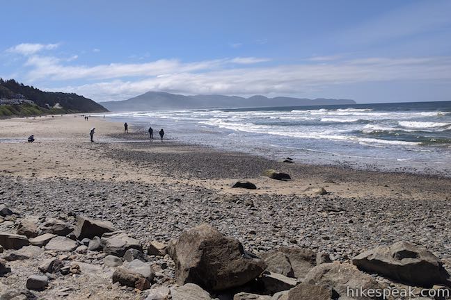
To shuffle toward Oceanside Tunnel, turn right and walk north across the sand. If you stray to the left, you’ll be walking toward Netarts Bay. The beach is wide open in that direction, with nothing to block your path that would require a tunnel.
Walk north up Oceanside Beach toward Maxwell Point, where cliffs form a wall at the north end of the beach. At the base of the cliffs at the back of the beach, look for an out-of-place tunnel entrance and head toward it.
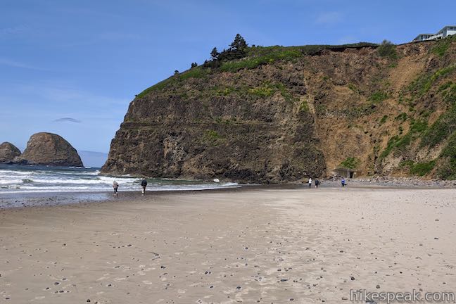
As you travel up the beach, enjoy views of the Three Arch Rocks, a cluster of rock islands with natural tunnels carved through them by the waves. This wild and beautiful offshore formation is a protected national wildlife refuge where sea lions raise their pups and sea birds nest.
After less than a quarter mile of beach walking, come to the mouth of the man-made tunnel carved into the cliffs. A fallen rock warning sign is posted next to the tunnel entrance. Looking up the adjacent cliffs, the risk of a rock fall is clear. Be cautious and move quickly.
The start of the tunnel is a molded concrete corridor with small round windows cut into the ocean side that let in light and allow you to peak back out at the beach. Venture deeper into the tunnel where the well-formed concrete structure is replaced by rough rocky walls and a lumpy floor. The tunnel is only about 125 feet long from end to end, so light from the tunnel exit is visible almost immediately. Watch your step as you proceed over the uneven floor. Light your path with the a flashlight or a headlamp if you brought one (a smartphone flashlight is sufficient).
As you clamber over the rocks, you might be asking yourself – what’s the story behind this tunnel? What’s the history? Why is it here? While building the first vacation resort in Oceanside, the Rosenberg family carved out the tunnel to create greater beach access for guests. In 1968, according to Oceanside Beach State Recreation Site’s official webpage, Orin and Lorraine Rosenburg gifted the first parcel of land that became the public beach park, which included Maxwell Point and the beach access tunnel.
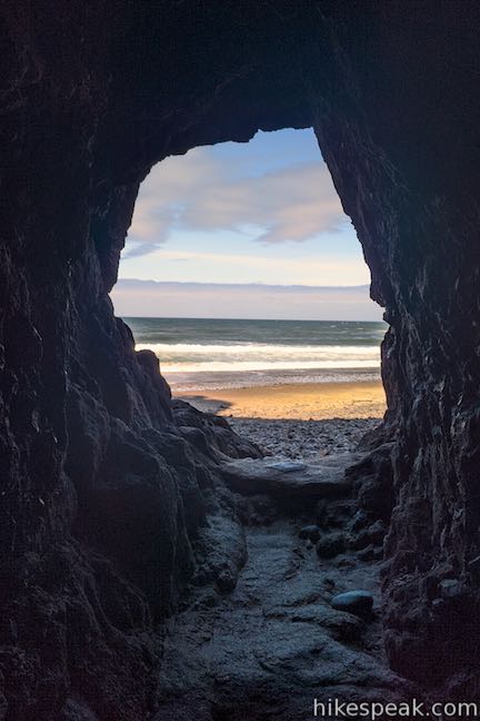
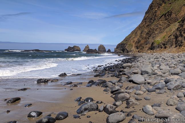
Framed by the oval opening at the end of the cave, a secret beach appears! Make your way out of the north end of the tunnel. In front of you is a postcard-worthy piece of the Oregon coast. Tunnel Beach is a cobblestone beach that is about 300 yards long, framed by Maxwell Point to the south and another barrier at the far end made up of a string pointed rocks.
With fewer visitors than Oceanside Beach, Tunnel Beach looks much more rugged. It feels like oceanfront that has barely been touched by humans (ignoring, of course, the tunnel you just came through). Tunnel Beach boasts an excellent perspective of the Three Arch Rocks, as this is about as close as you can get to those islands without leaving the shore.
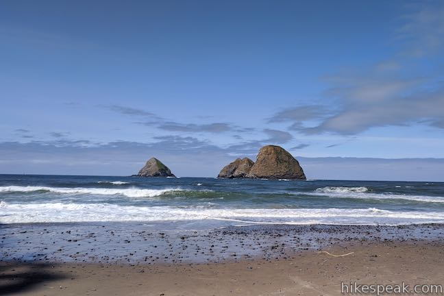
Walk up Tunnel Beach as far as you like.
It is probably safest not to go past the stroll-able section of the beach by attempting to forge through the rocks and surf beyond. At low tide and with wet feet, it may be feasible to reach a small beach on the other side of the rocks north of Tunnel Beach. Rip tides are present, so it is safest not to attempt traveling past Tunnel Beach. Instead, turn around and walk back down Tunnel Beach. The scenery is wonderful. What more could you want?
When you come back to Maxwell Point, just like at Oceanside Beach on the other side, the tall cliffs extend out into the ocean and prevent any further walking on the sand. Veer inland to the easy-to-spot mouth of the tunnel. Climb inside and make your way through. Pop out the tunnel’s other end onto Oceanside Beach and stroll back to the day use parking area (or press on and walk farther south down the beach).
No fee is required to visit Oceanside Beach State Recreation Site and no permit is needed to walk to Tunnel Beach. Bathrooms are available at the trailhead and leashed dogs are welcome. Sandcastles are encouraged. Enjoy your time at the beach!
To get to Oceanside Beach State Recreation Site: From the intersection of Highway 101 and Route 6 in Tillamook, head west on Netarts Highway (Route 131), which is straight across Highway 101 from Route 6 for those traveling from Portland. Take Route 131 southwest for 5 miles and pass Whiskey Creek Road, the route to Cape Lookout. Drive another 3.8 miles on Netarts Oceanside Highway (Route 131), traveling northwest up the coast. Reach an intersection at the edge of Oceanside and turn left to stay on Route 131 following signs for Oceanside. (The road to Cape Meares is to the right.) Drive another quarter mile, come to a stop sign, and turn left down the road into the parking area for Oceanside Beach State Recreation Site. The path down to the sand begins at the south end of the parking area.
Trailhead address: Oceanside Beach State Recreation Site, Rosenberg Loop, Tillamook, OR 97141
Trailhead coordinates: 45.4605, -123.9700 (45° 27′ 37.8″N 123° 58′ 12″W)
You may also view a regional map of surrounding Oregon trails and campgrounds.
 | Cape Meares Lighthouse & Octopus Tree This easy 0.8-mile hike in Cape Meares State Park visits a beautiful lighthouse and an equally impressive tree, exploring a coastal cape with tall cliffs and big ocean views. |
 | Cape Lookout Trail This 5-mile round trip hike ventures down a promontory on the Oregon Coast with beautiful ocean views. |
 | Cape Kiwanda This short beach hike explores tide pools and sand dunes at a rugged headland on Oregon's coast near Pacific City. |
 | Ecola Point to Indian Beach This 2 2/3-mile round trip hike explores a wild and beautiful section of Oregon Coast Trail between Ecola Point and Indian Beach in Ecola State Park. |
 | Whalen Island Loop Trail This 1.5-mile hike explores a lovely island-like park in Sand Lake Estuary with ocean and wetland views. |
 | Munson Creek Falls Trail This short hike near Tillamook travels up a forest canyon to the tallest waterfall in Coastal Oregon. |
 | Saddle Mountain Trail This 5-mile round trip hike rises through fir forests and wildflower-filled slopes up to a summit with panoramic coastal views. |
 | Beaver Falls This short hike slips down through forest to a beautiful waterfall plunging over a basalt wall. |
 | Trails in Oregon Explore more hikes throughout the state of Oregon. |
 | Whalen Island County Campground This 33-site campground is a nice camping option on Whalen Island with easy access to estuary beaches and a loop hike. |
 | Cape Lookout State Park Campground This grand, oceanfront campground has over 200 sites right behind a big, beautiful beach. |
Oceanside Beach to Tunnel Beach on theoutbound.com
Tunnel Beach on beachconnection.net
Tunnel Beach on tillamookheadlightherald.com
A Sacremento Bee article about a landslide the blocked Oceanside Tunnel in 2020
Oceanside on visittheoregoncoast.com
The official webpage for Oceanside Beach State Recreation Site


This is an outdated story, and hike. There was a rock slide about a year ago that covered the enterance to the tunnel.
So far, there have been no talks, nor interest, in opening up the access to the tunnel.
The rock slide was cleared and the tunnel was open this May (2021)
Tunnel is all cleared. I went through it yesterday.
Where is the beach that you can hunt and find agates?
I was almost killed by a rock slide on March 21, 2022. Don’t go there without a rock hard hat. Also it’s very scary to go there during high tide because a giant wave came crashing at us while we were running away from the rock slide. We almost got swept away by though under tide. This place is extremely dangerous
Where is the entrance to the tunnle? How long is the tunnle to walk thru?