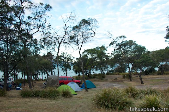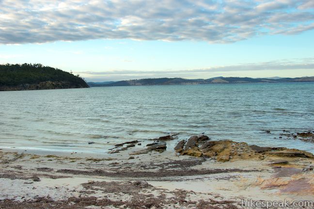
If you’re on the lookout for a campground on the Tasmanian coast with grassy plots shaded by eucalyptus trees, don’t overlook Lime Bay State Reserve. This off-the-beaten-path campground is located on a remote thumb of the Tasman Peninsula, set in a picturesque bay with light sand beaches framing the campground on both sides.

Lime Bay State Reserve protects a point at the northwest corner of the Tasman Peninsula in southeast Tasmania. Lime Bay has a relatively primitive campground with non-powered sites only. The sites are not numbered, but you’ll find numerous places to set up camp along a loop at the end of Coal Mines Road.
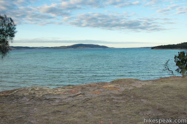
The campground is spread along a shelf just above the water with views looking northeast over Norfolk Bay. The campground is at the center of a cove, with crescent-shaped beaches on both sides. The beaches are perfect for leisurely strolls and the tapered sand extends a long way out into the bay, making this a nice place to swim and play in calm, sheltered waters. Black swans enjoy floating around the bay as well.


All sites are first-come first-served and reservations are not accepted. Fire rings are spread around the campground and ground fires are allowed, unless a total fire ban is in place (which can go into effect at short notice). The park service recommends cooking meals on fuel stoves. If you plan to have a fire, bring your own wood. Chainsaws and wood gathering are prohibited. Pets and firearms are also not welcome. Generators are allowed until 10 p.m. No drinking water is available at the campground, so bring your own. A four-stall toilet block is set back from the campground where the toilets flush with a pump.
The prices to camp at Lime Bay State Reserve are as follows:
- $13 per night for one or two people
- $5 per night an extra adult
- $2.50 per night for an extra child age 5 – 17 (younger children are free)
- $16 per night for a family of two adults and three children
Wallabies can be seen in and around the campground early in the morning and in the evening.
On weekends, you may overhear other camping groups playing music at night. The area is peaceful otherwise, and the beaches are perfect for moonlight strolls. During the day, several places to hike are nearby, including Coal Mines Historic Site, which you must pass to reach the campground. The combination of shade, beaches, and campfires makes Lime Bay State Reserve a really desirable place to camp.
Directions to the campground: Take Tasman Highway (A3), 25 kilometers east of Hobart to the town of Sorell. You will come to an intersection in the center of town where A3 makes a 90-degree turn. Take the road leaving A3 at this intersection, which is Coles Street/Arthur Highway (A9). This will be a right turn if you are coming from Hobart. Drive 60 kilometers on A9 to the Tasman Peninsula and turn right onto Nubeena Road (B37), which is just past the Tasmanian Devil Conservation Park and 9.5 kilometers past Eaglehawk Neck. Drive 9 kilometers on B37 and turn right on Saltwater River Road (C341), following signs for Saltwater River and Coal Mines Historic Site. Go 9.4 kilometers and turn right on Coal Mines Road, following a sign for Lime Bay State Reserve. The road becomes unpaved as you drive 6.5 kilometers to the campground at the end of the road.
Campground address: Coal Mines Road, Sloping Main, TAS 7186, Australia
Campground coordinates: -42.956901, 147.704245 (42° 57′ 24.84″S 147° 42′ 15.28″E)
Use the map below to view the campground and get directions:
Or view Australian trails, campgrounds, and lodging in a larger map
 | Coal Mines Historic Site This 0.8-kilometer loop through the Convict Precinct explores the ruins of an old prison and coal mine that relied on convict laborers. |
 | Cape Raoul This 12 to 14-kilometer hike explores the pristine coastline at the southwest end of the Tasman Peninsula, reaching a cape with daunting 200-meter tall cliffs dropping to swirling seas. |
 | Blowhole & Fossil Bay Lookout This short walk in Tasman National Park reaches a coastal vista point and a wave-carved tunnel through a rocky point that has the potential to spray up like a whale spout. |
 | Tasmans Arch & Devils Kitchen This 0.9-mile walk visits two impressive features on the coast of the Tasman Peninsula, a natural bridge and a chasm carved by the sea. |
 | Friendly Beaches This hike explores a long, pristine beach on the east coast of Tasmania north of the Freycinet Peninsula. |
 | Cape Tourville This 0.6-kilometer circuit provides big views along the east coast of Freycinet Peninsula, circling 100-meter tall bluffs to reach the Cape Tourville Lighthouse. |
 | Wineglass Bay and Hazards Beach Circuit This approximately 12-kilometer loop takes a rewarding route through Freycinet National Park, visiting pristine light sand beaches at Hazards Beach and the renowned Wineglass Bay. |
 | Apsley Waterhole & Lookout Track This 1.4-kilometer loop travels through a eucalyptus forest to a popular swimming hole on the Apsley River in Douglas-Apsley National Park. |
 | Saint Columba Falls This 1.2-kilometer round trip hike descends into a rainforest to the base of a powerful 90-meter tall waterfall. |
 | Mount William This 3.6-kilometer out and back hike tops a short summit that is the high point of Mount William National Park with panoramic views over the coastline at the northeast corner of Tasmania. |
 | Pinnacles Boardwalk & Summit Trig The 0.3-kilometer round trip walk on Pinnacles Boardwalk can easily be extended to a 0.75-kilometer walk on the top of Mount Wellington, checking out another short boardwalk and the trig station at the summit. |
 | Octopus Tree and Circle Track This 1.1-kilometer loop in Hobart’s Wellington Park reaches a unique eucalyptus tree with tentacles for roots that wrap around a boulder. |
 | Cataract Gorge This 3.4-kilometer loop combines Zig-Zag Track, Cataract Walk, and Bridge Walk to explore Cataract Gorge Reserve, an impressive natural area just outside the center of Launceston. |
 | Liffey Falls This 2.2-kilometer walk passes the Upper Cascades on the Liffey River to reach the base of lovely Liffey Falls, one of Tasmania’s finest waterfalls. |
 | Russell Falls & Horseshoe Falls This hike in Mount Field National Park visits one of Tasmania’s most famous and beautiful waterfalls and can be extended from 1.8 to 2.65 kilometers by venturing to the top of Russell Falls and nearby Horseshoe Falls. |
 | More trails in Australia Explore other destinations in Victoria and Tasmania, Australia. |
 | Mayfield Beach Conservation Area Campground This beachfront campground is located on Great Oyster Bay on the east coast of Tasmania. |
 | Friendly Beaches Campground This primitive campground offers oceanfront camping surrounded by beautiful beaches in Freycinet National Park. |
 | Big4 Iluka on Freycinet Holiday Park This holiday park in the coastal town of Coles Bay at the top of Freycinet Peninsula offers tent sites, campervan sites, and cabins, as well as quick access to nearby Freycinet National Park. |
 | Richardsons Beach Campground This bay side campground near Coles Bay offers powered and non-powered campsites in Freycinet National Park. |
 | Stumpys Bay Campground This campground is split into four areas along Stumps Bay with numerous campsite for visitors to Mount William National Park. |
 | Big4 Launceston Holiday Park This holiday park in Launceston offers tent sites, campervan sites, and cabins on a hillside near the city center. |


Hello, my friend and me want to visit Tasmania from 1st – 6th. I just want to make sure that we don’t have to book this camping ground. I know that it is not sure if we get a place. So we can come, pay the fee for the national park and camp there for free?
Kind regard Michelle Ocker
Correct. Campsites can’t be reserved
hello, My friends and i want to camp at lime bay from the 8th-10th may, what we want to know is
Are we allowed to have a fire?
Is there any power spots ?
Do we need a camping pass ?