Hoegees Camp via Lower Winter Creek Trail
in the San Gabriel Mountains

Hoegees Camp lies along Winter Creek in the canyon adjacent to Sturtevant Falls. Both trails begin from Chantry Flats. And while the hike to Hoegees Camp does not offer a waterfall, it does offer a 4.25-mile out-and-back hike through a lush canyon with 700 feet of elevation change. You may also continue on Upper Winter Creek Trail to return to Chantry Flats for a 4.85-mile loop with 1,000 feet of elevation change.

The directions are fairly straightforward. Set out from Chantry Flats and descend the paved trail for 0.6 miles to Roberts Camp. After crossing the bridge at the bottom of the pavement, come to a junction. Instead of proceeding straight up Gabrielino Trail to Sturtevant Falls, turn left onto Lower Winter Creek Trail.
Lower Winter Creek Trail
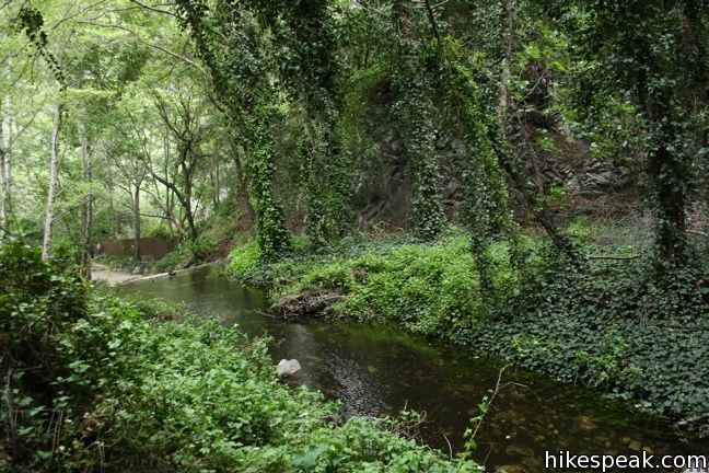
Make your way along Winter Creek past a few wilderness homes and concrete dams as you hike up Lower Winter Creek Trail through a lot of greenery. A small cave off the side of the trail, a quarter mile from the junction, appears to be from an abandoned mine.
The forest along Lower Winter Creek Trail is delightful. Compared to Gabrielino Trail to Sturtevant Falls, Lower Winter Creek Trail is narrower, but not much steeper and a lot less crowded.
Hoegees Camp
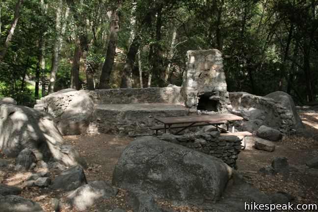
From 1907 to 1953 (when it burned down) Hoegees Camp served as a resort for hikers. Today Hoegees Camp offers vault toilets, picnic tables, and fire rings. The fourteen campsites are first-come first-serve (no reservations) for no fee (free of charge). The trail camp is open year round.

Hoegees Camp is located at an elevation of approximately 2,500 feet. Chantry Flats is at 2,150 feet, but the hike dips to 1,800 feet at Roberts Camp in between.
To venture past Hoegees Camp, continue up Mount Zion (and beyond to complete the Santa Anita Canyon Loop), or loop back to Chantry Flats on Upper Winter Creek Trail. Both extensions can be found at a junction 0.2 miles above the campground at the end of Lower Winter Creek Trail.
Dogs are welcome on leashes. A National Forest Adventure Pass is required for vehicles parked at Chantry Flats Trailhead. No permit is needed to hike to Hoegees Camp, so get out and enjoy!
To get to the trailhead: Take the 210 Freeway to Arcadia, east of Pasadena. Use exit 32 for Santa Anita Avenue and head north at the end of the offramp. Drive 5 miles up Santa Anita Avenue, going into the mountains. The road ends at Chantry Flats.
Trailhead address: Chantry Flats Road, Angeles National Forest, Arcadia, CA 91006
Trailhead coordinates: 34.1955, -118.0225 (34° 11′ 43.8″N 118° 01′ 21″W)
View Santa Anita Canyon in a larger map
Or view a regional map of surrounding Los Angeles trails and campgrounds.
Winter Creek Trail to Hoegees Camp


Lower Zion Trail from Hoegees Camp to Mount Zion


Upper Zion Trail from Spruce Grove Camp to Mount Zion


Gabrielino Trail to Spruce Grove Camp


 | Upper Winter Creek Trail This 2.75-mile long trail can be used to extend Santa Anita Canyon Loop or create a 4.85-mile loop with Lower Winter Creek Trail. |
 | Lower Zion Trail The trail from Hoegees Camp up Mount Zion is 1.5 miles long. |
 | Spruce Grove Camp This 8-mile in-and-out or 9.5-mile loop takes hikers beyond Sturtevant Falls to a backcountry campground with seven first-come first-serve sites. |
 | Sturtevant Falls This 3.3-mile hike visits a 60-foot waterfall and a lush cottage-lined canyon. |
 | Hermit Falls This 2.5-mile heads down canyon away from Sturtevant Falls toward a 30-foot waterfall. The lush canyon and the babbling creek are quite calming. |
 | Santa Anita Canyon Loop This 9.5-mile loop visits two peaceful creeks in sylvan canyons, passing a 60-foot waterfall and plenty of beautiful wilderness. |
 | More trails in the San Gabriel Mountains Explore other destinations in the range. |
 | Dawn Mine This 6-mile hike from Millard Campground leads past Millard Falls to an old gold mine. |
 | Fish Canyon Falls This 4.8-mile round trip hike leaves from an active rock quarry and progresses up a beautiful canyon to a mesmerizing multi-tiered waterfall. |
 | Mount Waterman The 5.5 to 6 miler can be completed as an out and back hike or a loop, traveling through a pine forest to a round summit. Add six miles to the hike by dropping across a saddle and climbing to the summit of Twin Peaks. |


This was a beautiful place to go hiking and camping but be careful with what you bring with you and keeping it protected from bears. When I camped here we choose to camp under the stars instead of using a tent and were not happy to wake up to a bear and her cub trying to get to some of our food! The people I was camping with had been to this site numerous times for boyscouting campouts and hadn’t come across any bears but they kept coming back to us. Scared them off twice before dawn and then backpacked out of there in the morning.
Is the campground already packed for the weekend?
How many camp sites are there? How many miles from Adam’s Pack Station? I can buy the camping permit at Adam’s Station correct? I’m sorry, too many questions. I’m excited to go camping to this place.
Hi I have to make reservations for do camping there? And yes how much?
Hi – There are no reservation. Each site is first-come first-serve. There is no charge to stay at this trail camp.
Hi, is there water at Hogees Camp right now?
What kind of wildlife is there?
Lots of squirrels, chipmunks, owls, sometimes bears, and lots of other creatures that make noise through the night.
Is there a place where we can filter water nearby
I was at Hoegees Trail Camp (Nov 11-12) and there was still water in the stream. Just enough to filter.
Beware… We had a big bear problem at this site. Momma and baby cub in our campsite all night long.
Just got back from an overnight at Hoegee’s camp – went on a summer weekday and we were the only ones camping. A bear wandered through the camp in the evening and didn’t seem to respond to shouting and banging pots – he looked like he was just passing through. Definitely bring a bear can.
It was nice that this was almost entirely shaded. Nonetheless, in the summer, because it’s still a fairly low elevation, it stays pretty hot.
We went on this hike today, the first of September. Didn’t see any bears but OH THE BUGS!! We decided to turn around just after Hoages, the bugs were hellish. I’m guessing they are a seasonal thing, but for us they made a gorgeous hike totally undoable.