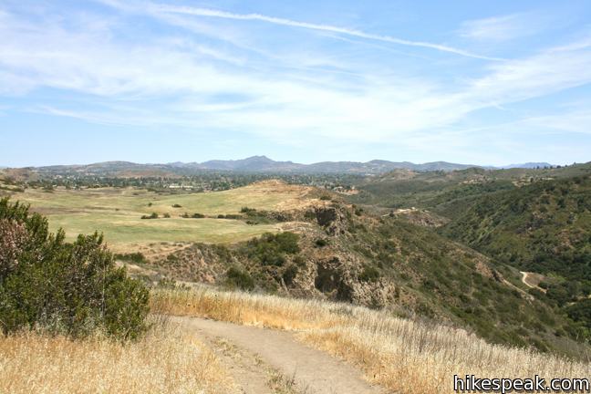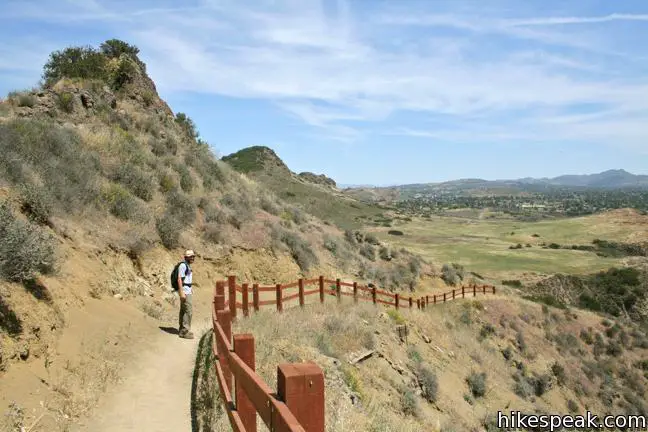
To add extra mileage and views to a visit to Paradise Falls in Thousand Oaks, consider placing Lizard Rock on your itinerary. Lizard Rock rises over five hundred feet from the canyon below to offer fine views of Stagecoach Bluff and beyond. This write-up describes a 4.35-mile loop with 570 feet of elevation change that visits both Lizard Rock and Paradise Falls.
Two routes to Lizard Rock are available from the park entrance. Stagecoach Bluff Trail runs along the rim of the canyon and is longer and more scenic with a few winding passages along the canyon wall. Mesa Trail is more direct and is the route you would actually want to drive a stagecoach down (if that was your mode of transportation). The trail is wide and runs straight up the gut of the park.
Take the most obvious trail departing the parking area for Wildwood Park and head straight west on Mesa Trail. Cross over a rise and pass through a few early junctions. After 0.35 miles of hiking, you will come to a junction with North Tepee Trail. If you wish to take Stagecoach Bluff Trail to Lizard Rock or hike down to Paradise Falls, turn left. Otherwise, continue straight on Mesa Trail, saving North Tepee Trail for the hike back.
Hike another half mile up Mesa Trail and bear left at a split. After 1.05 miles on Mesa Trail, you will come to a junction with the far end of Stagecoach Bluff Trail. Hike another tenth of a mile mile to the end of Mesa Trail, enjoying views over your shoulder across Stagecoach Bluff. Proceed onto Lizard Rock Trail, which is narrower than Mesa Trail and 1.2 miles long.

Lizard Rock Trail immediately passes below Lizard Rock, which juts out from the terrain. Leaving Lizard Rock, stay left past a spur to proceed down Lizard Rock Trail through a string of switchbacks that wind down into Wildwood Canyon. This is a shared trail, so watch out for bikers speeding down the twists and turns. The trail here is surprisingly steep. Attempting this hike in reverse requires much more effort.

The trail carves along the side of the canyon above a large water treatment facility that is downstream from Paradise Falls. Turn left at the bottom of Lizard Rock Trail, heading upstream on Wildwood Canyon Trail.
Enter a grove of Sycamores and pass through Skull Hollow Picnic Area. Wildwood Canyon Trail provides a pleasant stroll through shade next to the Arroyo Conejo. After just 0.37 miles on Wildwood Canyon Trail, you will come to a split. Bear left to hike up Tepee Trail or continue straight on Wildwood Canyon Trail, which will lead you straight to Paradise Falls.
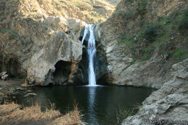
Follow the posted signs to descend to the right to Paradise Falls, which plunges 40 feet into a large pool. A rock grotto on the left side of the waterfall looks alien from the surrounding landscape. Use stepping stones to cross through a line of cattails below the pool to get the best perspective of Paradise Falls from the opposing bank, where rock outcroppings create relaxing seats.

You will reach Paradise Falls after about 3.25 miles of hiking by following this route past Lizard Rock. To return to the trailhead, hike back up Paradise Falls Trail to Wildwood Canyon Trail. Turn right and make an immediate left onto an upper section of Paradise Falls Trail. Reach Tepee Trail and turn right. When you come to a junction by a recreated tepee, turn left up North Tepee Trail. This trail leads back to Mesa Trail, where you can turn right to hike back to the trailhead.
The basic directions for a loop to Lizard Rock and Paradise Falls:
- Begin hiking west on Mesa Trail (0 miles)
- Pass North Tepee Trail, the return route (0.35 miles)
- Bear left to stay on Mesa Trail (0.85 miles)
- Pass Stagecoach Bluff Trail (1.05 miles)
- Proceed onto Lizard Rock Trail (1.15 miles)
- Pass Lizard Rock (1.17 miles)
- Descend to the bottom of Lizard Rock Trail and turn left on Wildwood Canyon Trail (2.35 miles)
- Bear left Tepee Trail or stick with Wildwood Canyon Trail (2.72 miles)
- Turn right down Paradise Falls Trail (3.09 miles)
- Turn right on Wildwood Canyon Trail (3.20 miles)
- Turn left down a trail to Paradise Falls (3.22 miles)
- Enjoy Paradise Falls (3.28 miles)
- Hike back up to Wildwood Canyon Trail and turn right (3.34 miles)
- Turn left up the upper section of Paradise Falls Trail (3.36 miles)
- Return to Tepee Trail and turn right (3.47 miles)
- Turn left up North Tepee Trail (3.6 miles)
- Turn right on Mesa Trail (4 miles)
- Return to the trailhead (4.35 miles)
Wildwood Park has additional attractions. If you would like to take a 4.75-mile hike to Lizard Rock, Paradise Falls, and Indian Cave, combine the directions above with the directions back from Paradise Falls described here.
No fee or permit is required to visit Lizard Rock and Paradise Falls in Wildwood Park. Dogs and bikes are welcome, so get out and enjoy!
To get to the trailhead: take the 101 Freeway to exit 45 in Thousand Oaks. Drive north for 2.5 miles on Lynn Road. Turn left on Avenido de los Arboles and park in the lot at the end of the street.
Trailhead address: 928 West Avenida De Los Arboles, Wildwood Regional Park, Thousand Oaks, CA 91360
Trailhead coordinates: 34.2200, -118.9028 (34° 13′ 12″N 118° 54′ 10″W)
View Thousand Oaks in a larger map
Or view a regional map of surrounding Los Angeles trails and campgrounds.
 | Paradise Falls This 40-foot waterfall spills into a large pool along the Arroyo Conejo. Paradise Falls is located within Wildwood Park in Thousand Oaks and is reachable via several trails. |
 | Tarantula Hill This 1-mile round trip hike follows a paved trail to the top of a small, round hill in Thousand Oaks with views across the Conejo Valley into the surrounding mountains. |
 | Oak Creek Canyon Trail This 0.8-mile loop starts with an all-access nature trail with signs in English and Braille before transitioning to a less developed dirt single track, looping through chaparral and oak woodlands in Los Robles Open Space. |
 | Angel Vista via Rosewood Trail This 4-mile round trip hike is the most direct route to a panoramic viewpoint overlooking the Conejo Valley. |
 | Angel Vista via West Los Robles Trail This 7.6-mile round trip hike is a more gradual route to the overlook on the north side of the Santa Monica mountains. |
 | More trails in Los Angeles Explore other hiking destinations around Los Angeles. |


Nice hike, although busy trails and very, very hot. While the trails are plentiful, you will still run into people of all ages, people with dogs, etc. While the trails are large enough to accommodate, there is very little shade and the sun around 9AM was beating down pretty hard. Regardless, the hike up to Lizard Rock was great. Slightly steep in places but the view was nice and it was worth the effort.
Have they open up the azusa Garcia hiking trail
Where does the water come from for the falls?
Loved every minute of the hike and the Indian cave. the falls were stunning