Regions of New Zealand
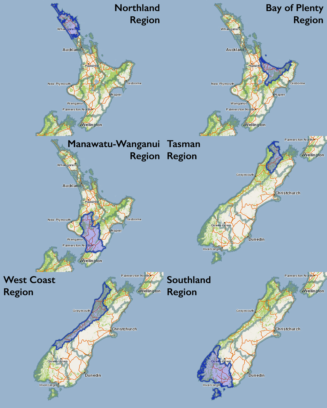
New Zealand’s islands are divided into several regions for governing and tourism. There are nine regions on the North Island and seven regions on the South Island. While not as distinct as states, each region does have some autonomy.

As hikespeak expands in New Zealand, it will become easy to search by region. Here is a list of regions and their highlights:
Northland Region – The northernmost region on the North Island has few towns and cities, but lots of pristine beaches, kauri forests, and waterfalls. Northland boasts the world’s largest kauri tree, found in Waipoua Forest. Popular destinations are Bay of Islands and Ninety Mile Beach.
Auckland Region – Located at the north end of the North Island, just south of Northland, the Auckland Region contains the city of Auckland, which is New Zealand’s biggest city, with a population close to 1.5 million, or about a third of the country’s population.
Waikato Region – The Waikato Region (south of the Auckland Region) is incredibly diverse and contains many of the North Island’s top attractions. The Coromandel Peninsula is a popular vacation spot for Kiwis, with Hot Water Beach and great coastal areas. The Lord of the Rings Tourism Park, Hobbiton, is located near Hamilton. Waitomo has several caves that can be explored on tours. Taupo, at the south end of the region, has geothermal features around beautiful Lake Taupo, New Zealand’s largest lake by surface area.
Bay of Plenty Region – This region is based around the large bay south of Coromandel Peninsula. There are beautiful beaches around the city of Tauranga, and inland, the region is home to Rotorua, which has incredible geothermal features.
Gisborne Region – This region covers the remote east end of the North Island.
Taranaki Region – This region on the west coast of the center of the North Island includes Mount Taranki (Mount Egmont), a standout volcano in Egmont National Park.
Manawatu-Wanganui Region – This large region includes two national parks, Whanganui National Park and Tongariro National Park. This region stretches south toward Palmerston North.
Hawke’s Bay Region – This region covers the southeast coast of the North Island and includes the art-deco city of Napier (and its surrounding wineries) and Te Urewera National Park, which surrounds Lake Waikaremoana.
Wellington Region – The southernmost region on the North Island surrounds the city of Wellington, the capital of New Zealand.
Tasman Region – This is the northernmost region of the South Island, starting at Farewell Spit above Golden Bay. The region includes Kahurangi National Park, Abel Tasman National Park, and Nelson Lakes National Park.
Nelson Region – This small region contains the lovely city of Nelson on the north coast of the South Island.
Marlborough Region – This region at the northeast end of the South Island includes the city of Picton, where your ferry will land if you boat over from Wellington.
West Coast Region – This region covers most of the west coast of the South Island. Paparoa National Park, Westland National Park, and Mount Aspiring National Park are all in this region. Franz Josef Glacier and Fox Glacier, the most accessible glaciers in the Southern Alps, are both on the west coast.
Canterbury Region – This region on the east coast of the South Island includes Christchurch, the largest city on the South Island. The region covers the east side of the Southern Alps, where you can visit Arthur’s Pass National Park and Mount Cook (Aoraki) National Park.
Otago Region – This region is toward the south end of the Sough Island and includes the mountain city of Queenstown and the coastal city of Dunedin. This is a popular wine region with plains leading up to dramatic mountains.
Southland Region – This region covers the remote and rugged south end of the South Island and includes Fiordland National Park, which contains some of New Zealand’s most famous hiking tracks.
Or explore hikes in New Zealand on the Oceania Hike Finder Map


